IMAGES TAKEN NEAR TO
Sea Avenue, LITTLEHAMPTON, BN16 2DR
Introduction
This page details the photographs taken nearby to Sea Avenue, BN16 2DR by members of the Geograph project.
The Geograph project started in 2005 with the aim of publishing, organising and preserving representative images for every square kilometre of Great Britain, Ireland and the Isle of Man.

There are currently over 7.5m images from over14,400 individuals and you can help contribute to the project by visiting https://www.geograph.org.uk
Image Map
Images are licensed for reuse under creativecommons.org/licenses/by-sa/2.0
Notes
- Clicking on the map will re-center to the selected point.
- The higher the marker number, the further away the image location is from the centre of the postcode.
Image Listing (74 Images Found)
Images are licensed for reuse under creativecommons.org/licenses/by-sa/2.0
Image
Details
Distance

3
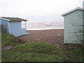
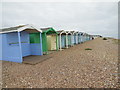
Looking between the beach huts on Broadmark Beach
Image: © Basher Eyre
Taken: 16 Jan 2010
0.04 miles
4
Looking from Broadmark Beach into Sea Avenue
Image: © Basher Eyre
Taken: 16 Jan 2010
0.04 miles
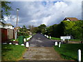
5
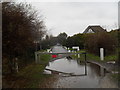
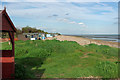
Rustington, Sea Avenue
Private road from the beach to Station Road.
Image: © Mike Faherty
Taken: 25 Aug 2018
0.04 miles
6
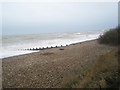
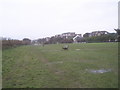
Not really the weather for a dip on Broadmark Beach
Besides, I have spotted a lamppost up ahead!
Image: © Basher Eyre
Taken: 16 Jan 2010
0.04 miles
10
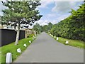
Sea Avenue, Rustington
From the sea front looking due north on to The Sea Estate www.worthingherald.co.uk/CustomPages/CustomPage.aspx?SectionID=4877
Image: © Peter Holmes
Taken: 19 Nov 2007
0.07 miles