IMAGES TAKEN NEAR TO
Ruston Avenue, LITTLEHAMPTON, BN16 2AN
Introduction
This page details the photographs taken nearby to Ruston Avenue, BN16 2AN by members of the Geograph project.
The Geograph project started in 2005 with the aim of publishing, organising and preserving representative images for every square kilometre of Great Britain, Ireland and the Isle of Man.

There are currently over 7.5m images from over14,400 individuals and you can help contribute to the project by visiting https://www.geograph.org.uk
Image Map
Images are licensed for reuse under creativecommons.org/licenses/by-sa/2.0
Notes
- Clicking on the map will re-center to the selected point.
- The higher the marker number, the further away the image location is from the centre of the postcode.
Image Listing (33 Images Found)
Images are licensed for reuse under creativecommons.org/licenses/by-sa/2.0
Image
Details
Distance
3
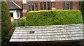
Corrugated roof on bus shelter and W.I.P. at Rustington Hall
My trip became a study of bus shelter roofs after I noticed some nice wooden shingles. But not on this one - yet! See Image] and Image
Image: © Chris
Taken: 11 Jun 2016
0.11 miles
4
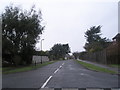
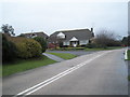
Looking from Pigeonhouse Lane into Hudson Drive
Image: © Basher Eyre
Taken: 16 Jan 2010
0.17 miles
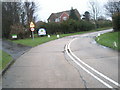
6
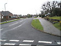
Junction of Pigeonhouse Lane and Jervis Avenue
Image: © Basher Eyre
Taken: 16 Jan 2010
0.18 miles
7
Road and path junction in Pigeonhouse Lane
Image: © Basher Eyre
Taken: 16 Jan 2010
0.19 miles
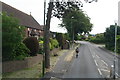
8
Wooden shingles, roof of St. Joseph's bus shelter, Rustington
Station Road.
Image: © Chris
Taken: 11 Jun 2016
0.19 miles
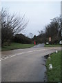
9
Approaching the junction of Pigeonhouse Lane and Jervis Avenue
Image: © Basher Eyre
Taken: 16 Jan 2010
0.19 miles