IMAGES TAKEN NEAR TO
Brookside Road, LITTLEHAMPTON, BN16 1SE
Introduction
This page details the photographs taken nearby to Brookside Road, BN16 1SE by members of the Geograph project.
The Geograph project started in 2005 with the aim of publishing, organising and preserving representative images for every square kilometre of Great Britain, Ireland and the Isle of Man.

There are currently over 7.5m images from over14,400 individuals and you can help contribute to the project by visiting https://www.geograph.org.uk
Image Map
Images are licensed for reuse under creativecommons.org/licenses/by-sa/2.0
Notes
- Clicking on the map will re-center to the selected point.
- The higher the marker number, the further away the image location is from the centre of the postcode.
Image Listing (55 Images Found)
Images are licensed for reuse under creativecommons.org/licenses/by-sa/2.0
Image
Details
Distance
1
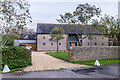
Sea Barn
19th Century barn, now converted to a home, in Brookside Road on the Kingston Gorse Estate. Grade II listed - see www.historicengland.org.uk/listing/the-list/list-entry/1027595.
Image: © Ian Capper
Taken: 26 Oct 2021
0.03 miles
3
Pump House, Oval Waye, Ferring
Ferring Rife runs behind these houses and is prone to flooding.
Image: © Simon Carey
Taken: 6 Aug 2017
0.09 miles
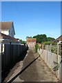
4
Private entrance to Gorse Avenue
One of the entrances from the beach to the private estate at Kingston Gorse
Image: © Josie Campbell
Taken: 26 Jul 2011
0.09 miles
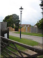
5
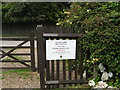
Kingston Gorse Private Estate notice
Image: © Josie Campbell
Taken: 26 Jul 2011
0.09 miles
6
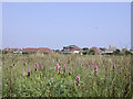
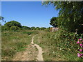
Marsh Orchids by Ferring Rife
In low-lying old brick earth diggings west of Ferring Rife is an enormous population of marsh orchids. The houses are on the other side of the Rife which is a local name for watercourses on the Sussex coastal plain. The rife is confined by river walls here.
Image: © Robin Webster
Taken: 31 May 2003
0.09 miles
8
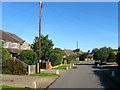
Oval Waye, Ferring
A residential road that runs in a crescent to the west of West Drive. It was developed from the mid 1920s onwards.
Image: © Simon Carey
Taken: 6 Aug 2017
0.12 miles
9
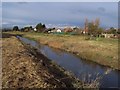
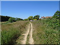
The Rife Ferring
Looking towards Highdown Hill to the north and to the south down to the sea.
Image: © anni stevens
Taken: 25 Nov 2005
0.13 miles
10
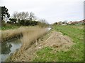
Ferring Rife
Drainage ditch flowing from the South Downs and draining into the Channel just to the South.
Image: © Mike Faherty
Taken: 9 Mar 2019
0.13 miles