IMAGES TAKEN NEAR TO
Kingston Lane, LITTLEHAMPTON, BN16 1RT
Introduction
This page details the photographs taken nearby to Kingston Lane, BN16 1RT by members of the Geograph project.
The Geograph project started in 2005 with the aim of publishing, organising and preserving representative images for every square kilometre of Great Britain, Ireland and the Isle of Man.

There are currently over 7.5m images from over14,400 individuals and you can help contribute to the project by visiting https://www.geograph.org.uk
Image Map
Images are licensed for reuse under creativecommons.org/licenses/by-sa/2.0
Notes
- Clicking on the map will re-center to the selected point.
- The higher the marker number, the further away the image location is from the centre of the postcode.
Image Listing (46 Images Found)
Images are licensed for reuse under creativecommons.org/licenses/by-sa/2.0
Image
Details
Distance
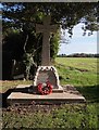
2
Kingston Gorse War Memorial, West Sussex
Link for more details on The Roll of Honour website.
http://www.roll-of-honour.com/Sussex/KingstonGorse.html
Image: © Philip Windibank
Taken: 27 Jun 2019
0.03 miles
4
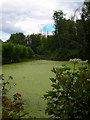
Pond, East Kingston
Taken from Sea Lane, the pond lies in the corner formed by the lane and the footpath/private drive that runs through East Kingston Farm.
Image: © Simon Carey
Taken: 20 Jul 2008
0.04 miles
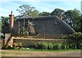
5
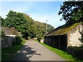
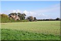
Outbuildings, East Kingston Farm, East Kingston
Image: © Simon Carey
Taken: 13 Aug 2017
0.04 miles
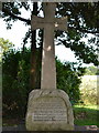
6
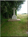
War Memorial, East Kingston
Tucked away at the end of the small hamlet of East Kingston on Sea Lane. The hamlet is part of the parish of East Preston so the four names of the local lads who died between 1914-18 are also included on the main village war memorial too. At this point the lane enters the private estate of Kingston Gorse and out of shot to the immediate left is a manned entrance. Whilst public right of way for vehicles ends here, the rest of the lane to the sea forms the route of a public footpath.
Image: © Simon Carey
Taken: 20 Jul 2008
0.04 miles
9
The Old Cottage, East Kingston
Built in the late 18th century and believed to be a former agricultural labourer's cottage.
Image: © Simon Carey
Taken: 13 Aug 2017
0.05 miles
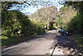
10
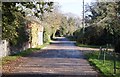
Lane by East Kingston Farm
A delightful corner untouched by surrounding modern developments.
Image: © Fernweh
Taken: 1 Nov 2014
0.05 miles