IMAGES TAKEN NEAR TO
Golden Avenue Close, LITTLEHAMPTON, BN16 1QS
Introduction
This page details the photographs taken nearby to Golden Avenue Close, BN16 1QS by members of the Geograph project.
The Geograph project started in 2005 with the aim of publishing, organising and preserving representative images for every square kilometre of Great Britain, Ireland and the Isle of Man.

There are currently over 7.5m images from over14,400 individuals and you can help contribute to the project by visiting https://www.geograph.org.uk
Image Map
Images are licensed for reuse under creativecommons.org/licenses/by-sa/2.0
Notes
- Clicking on the map will re-center to the selected point.
- The higher the marker number, the further away the image location is from the centre of the postcode.
Image Listing (49 Images Found)
Images are licensed for reuse under creativecommons.org/licenses/by-sa/2.0
Image
Details
Distance
5
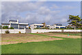
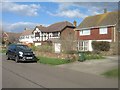
67 - 71 Coastal Road
Houses on Coastal Road in the West Kingston Estate, viewed from The Greensward. Nos 69 and 71 on the left, were built around the mid 2010s, replacing a single previous dwelling. No 67, on the right, was significantly altered around the same time, including the replacement of a pitched roof with a sun lounge. Although each is very different in design, there is an element of uniformity in the three buildings.
Image: © Ian Capper
Taken: 26 Oct 2021
0.14 miles

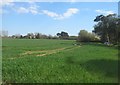
10
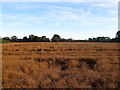
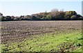
New Routed Piece/Little Green Croft
The name of the fields according to Kingston's 1841 tithe map that have been merged to form a larger unit. Little Green Croft was to the south whilst New Routed Piece was to the north adjacent to the public footpath beyond which is Image To the east is Kingston Lane whilst to the west are the houses of Golden Avenue, West Kingston.
Image: © Simon Carey
Taken: 13 Aug 2017
0.18 miles