IMAGES TAKEN NEAR TO
Clarence Drive, LITTLEHAMPTON, BN16 1EH
Introduction
This page details the photographs taken nearby to Clarence Drive, BN16 1EH by members of the Geograph project.
The Geograph project started in 2005 with the aim of publishing, organising and preserving representative images for every square kilometre of Great Britain, Ireland and the Isle of Man.

There are currently over 7.5m images from over14,400 individuals and you can help contribute to the project by visiting https://www.geograph.org.uk
Image Map
Images are licensed for reuse under creativecommons.org/licenses/by-sa/2.0
Notes
- Clicking on the map will re-center to the selected point.
- The higher the marker number, the further away the image location is from the centre of the postcode.
Image Listing (11 Images Found)
Images are licensed for reuse under creativecommons.org/licenses/by-sa/2.0
Image
Details
Distance
1
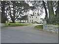
Preston Hall
Large house on The Street, dating from c1840. Grade II listed by Historic England: https://historicengland.org.uk/listing/the-list/list-entry/1027651
Image: © Mike Faherty
Taken: 13 Apr 2019
0.09 miles
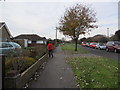
2
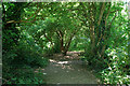
Wooded area, Langmead Recreation Ground
A scrap of woodland in this small park.
Image: © Robin Webster
Taken: 2 Jul 2010
0.14 miles
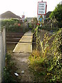
3
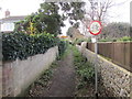
Footpath to St Mary's Church
Public footpath 2114 from The Street.
Image: © Peter Holmes
Taken: 29 Nov 2013
0.14 miles
4
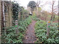
Footpath adjacent to Langmeads Field
Public footpath 2114 to St Mary's Church.
Image: © Peter Holmes
Taken: 29 Nov 2013
0.16 miles
5
St Mary's Drive
Public footpath 2114 from North Lane.
Image: © Peter Holmes
Taken: 29 Nov 2013
0.17 miles
6
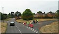
Road Block for street parade in East Preston
Some strangely dressed people passed us, being propelled along in oversized pushchairs.
Image: © Chris
Taken: 11 Jun 2016
0.17 miles
7
Footpath crossing West Coastway rail line
East Preston to Angmering footpath crossing West Coastway line between Angmering and Goring-by-Sea stations.
Image: © Peter Holmes
Taken: 14 Oct 2007
0.21 miles
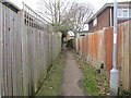
8
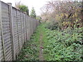
Path between fence and wild hedge
Public footpath 2114 to St Mary's Church.
Image: © Peter Holmes
Taken: 29 Nov 2013
0.21 miles
9
Footpath to St Mary's Drive
Public footpath 2114 from North Lane.
Image: © Peter Holmes
Taken: 29 Nov 2013
0.21 miles
10
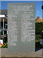
East Preston War Memorial
Located at the front of the public library, The Street, East Preston
Image: © Philip Windibank
Taken: 19 Sep 2019
0.23 miles