IMAGES TAKEN NEAR TO
Downs Way, LITTLEHAMPTON, BN16 1AE
Introduction
This page details the photographs taken nearby to Downs Way, BN16 1AE by members of the Geograph project.
The Geograph project started in 2005 with the aim of publishing, organising and preserving representative images for every square kilometre of Great Britain, Ireland and the Isle of Man.

There are currently over 7.5m images from over14,400 individuals and you can help contribute to the project by visiting https://www.geograph.org.uk
Image Map
Images are licensed for reuse under creativecommons.org/licenses/by-sa/2.0
Notes
- Clicking on the map will re-center to the selected point.
- The higher the marker number, the further away the image location is from the centre of the postcode.
Image Listing (5 Images Found)
Images are licensed for reuse under creativecommons.org/licenses/by-sa/2.0
Image
Details
Distance
1
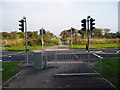
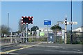
Footpath crossing A259
East Preston to Angmering footpath crossing A259 Roundstone By-pass Road at newly installed traffic lights.
Image: © Peter Holmes
Taken: 14 Oct 2007
0.05 miles
2
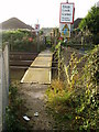
Footpath crossing West Coastway rail line
East Preston to Angmering footpath crossing West Coastway line between Angmering and Goring-by-Sea stations.
Image: © Peter Holmes
Taken: 14 Oct 2007
0.11 miles
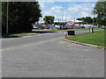
4

The Angmering School, Station Road
Taken from footbridge crossing A259 Roundstone By-pass Road.Webb site at :- www.angmeringschool.co.uk
Image: © Peter Holmes
Taken: 13 Nov 2007
0.23 miles