IMAGES TAKEN NEAR TO
Port Hall Place, BRIGHTON, BN1 5PN
Introduction
This page details the photographs taken nearby to Port Hall Place, BN1 5PN by members of the Geograph project.
The Geograph project started in 2005 with the aim of publishing, organising and preserving representative images for every square kilometre of Great Britain, Ireland and the Isle of Man.

There are currently over 7.5m images from over14,400 individuals and you can help contribute to the project by visiting https://www.geograph.org.uk
Image Map
Images are licensed for reuse under creativecommons.org/licenses/by-sa/2.0
Notes
- Clicking on the map will re-center to the selected point.
- The higher the marker number, the further away the image location is from the centre of the postcode.
Image Listing (176 Images Found)
Images are licensed for reuse under creativecommons.org/licenses/by-sa/2.0
Image
Details
Distance
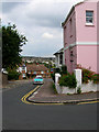
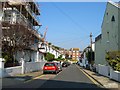
1
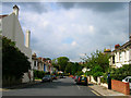
Port Hall Place
Looking down the length of the street from Port Hall Road to Port Hall Avenue. Developed in the early 1880s as a lower middle class suburb.
Image: © Simon Carey
Taken: 29 Aug 2007
0.01 miles
2
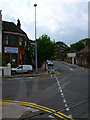
Brighton Plumbing and Heating Merchants
On the corner of Port Hall Avenue and Stanford Road.
Image: © Simon Carey
Taken: 29 Aug 2007
0.01 miles
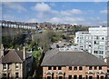
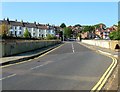
3
Dyke Road Drive Bridge
Carrying a minor road over the London-Brighton mainline. The houses are in Stanford Road.
Image: © Simon Carey
Taken: 2 Feb 2009
0.02 miles
4
Port Hall Place, Brighton
A residential road running between Port Hall Road and Port Hall Avenue that was developed between 1880-84.
Image: © Simon Carey
Taken: 4 Oct 2015
0.02 miles
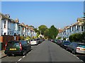
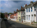
5
Port Hall Avenue
Looking down the road from its junction with Port Hall Street. The area was developed in the early 1880s as a lower middle class suburb.
Image: © Simon Carey
Taken: 29 Aug 2007
0.03 miles
6
Prestonville in Brighton
Prestonville is a largely residential area in the northwest of Brighton.
Image: © Mat Fascione
Taken: 18 Apr 2023
0.04 miles
7
Port Hall Street
Looking down towards its junction with Port Hall Avenue. The flats in the background are Elm Court. Developed in the early 1880s as a lower middle class suburb.
Image: © Simon Carey
Taken: 29 Aug 2007
0.04 miles
8
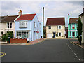
Filling the Gap
At the junction of Port Hall Road and Coventry Street a small gap in the late Victorian houses has been infilled by a newer one, the lack of chimney and inclusion of a garage being the giveaways. The blue house on the left in Port Hall Place looks like it had a previous life as a shop.
Image: © Simon Carey
Taken: 29 Aug 2007
0.04 miles
9
Port Hall Street, Brighton
A residential street running between Port Hall Road and Port Hall Avenue that was developed between 1880-84. Elm Court are the flats at the far end of the street.
Image: © Simon Carey
Taken: 4 Oct 2015
0.04 miles
10
Bridge, Dyke Road Drive, Brighton
Looking towards the junction seen in Image The houses on the left are in Stanford Road.
Image: © Simon Carey
Taken: 4 Oct 2015
0.04 miles