IMAGES TAKEN NEAR TO
Millcroft, BRIGHTON, BN1 5HD
Introduction
This page details the photographs taken nearby to Millcroft, BN1 5HD by members of the Geograph project.
The Geograph project started in 2005 with the aim of publishing, organising and preserving representative images for every square kilometre of Great Britain, Ireland and the Isle of Man.

There are currently over 7.5m images from over14,400 individuals and you can help contribute to the project by visiting https://www.geograph.org.uk
Image Map
Images are licensed for reuse under creativecommons.org/licenses/by-sa/2.0
Notes
- Clicking on the map will re-center to the selected point.
- The higher the marker number, the further away the image location is from the centre of the postcode.
Image Listing (51 Images Found)
Images are licensed for reuse under creativecommons.org/licenses/by-sa/2.0
Image
Details
Distance
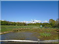
1
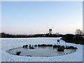
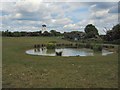
Dew Pond, Green Ridge
Constructed in 2000 to provide another wildlife habitat in this public open space. Beyond is Patcham Windmill.
Image: © Simon Carey
Taken: 20 Dec 2009
0.06 miles
2
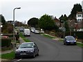
Westdene Drive, Westdene
Residential road linking Mill Rise to Hillcrest that is part of the estate that was built largely in the 1950s.
Image: © Simon Carey
Taken: 20 Jan 2013
0.06 miles
3
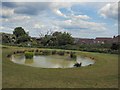
Dew Pond & Windmill
On the Green Ridge with the Patcham windmill in the background
Image: © Paul Gillett
Taken: 30 May 2010
0.06 miles
4
Green Ridge Dew Pond
Low level view with Patcham Windmill in the background
Image: © Paul Gillett
Taken: 30 May 2010
0.06 miles
6
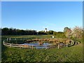
Dew Pond, Green Ridge
With Patcham Windmill beyond.
Image: © Simon Carey
Taken: 15 Apr 2020
0.07 miles
7
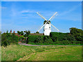
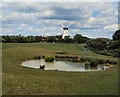
Patcham Windmill
Looking east. I was informed when taking the picture that it is apparently up for sale if anybody is interested.
Image: © Simon Carey
Taken: 3 Sep 2005
0.07 miles
8
Green Ridge Dew Pond and Patcham Windmill
Image: © Paul Gillett
Taken: 29 Apr 2017
0.08 miles
9
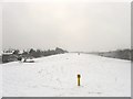
Green Ridge
Not living up to its name on this day. The strip of land between the suburb of Westdene and Mill Road is a public open space and local nature reserve between Patcham Towermill and Red Hill. To the left is the restored dew pond.
Image: © Simon Carey
Taken: 20 Jan 2013
0.08 miles