IMAGES TAKEN NEAR TO
Mill Rise, BRIGHTON, BN1 5GD
Introduction
This page details the photographs taken nearby to Mill Rise, BN1 5GD by members of the Geograph project.
The Geograph project started in 2005 with the aim of publishing, organising and preserving representative images for every square kilometre of Great Britain, Ireland and the Isle of Man.

There are currently over 7.5m images from over14,400 individuals and you can help contribute to the project by visiting https://www.geograph.org.uk
Image Map
Images are licensed for reuse under creativecommons.org/licenses/by-sa/2.0
Notes
- Clicking on the map will re-center to the selected point.
- The higher the marker number, the further away the image location is from the centre of the postcode.
Image Listing (47 Images Found)
Images are licensed for reuse under creativecommons.org/licenses/by-sa/2.0
Image
Details
Distance
1
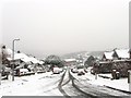
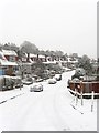
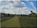
Mill Rise, Westdene
Viewed from the junction with Millcroft and Windmill Drive. The estate was built in the 1950s and is regarded as one of the nicer areas to live in the city though its position on the slopes of Coney Hill mean it often gets snowed in. In the distance is Image
Image: © Simon Carey
Taken: 20 Jan 2013
0.01 miles
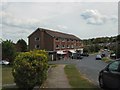
3
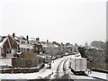
Bramble Rise, Westdene
Residential road linking Mill Rise to Copse Hill on an estate built in the 1950s.
Image: © Simon Carey
Taken: 20 Jan 2013
0.03 miles
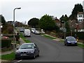
4
Westdene Drive, Westdene
Residential road linking Mill Rise to Hillcrest that is part of the estate that was built largely in the 1950s.
Image: © Simon Carey
Taken: 20 Jan 2013
0.05 miles
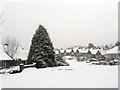
5
Highbank, Westdene
A residential road on the 1950s estate that links Mill Rise to Copse Hill.
Image: © Simon Carey
Taken: 20 Jan 2013
0.07 miles
6
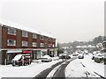
Loyal Parade, Westdene
A parade of shops on Mill Rise containing a dress agency, bridal gown shop, cash register salesroom, an off licence and Indian takeaway.
Image: © Simon Carey
Taken: 20 Jan 2013
0.07 miles
8
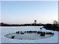
Dew Pond, Green Ridge
Constructed in 2000 to provide another wildlife habitat in this public open space. Beyond is Patcham Windmill.
Image: © Simon Carey
Taken: 20 Dec 2009
0.11 miles
10
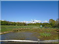
Green Ridge Dew Pond and Patcham Windmill
Image: © Paul Gillett
Taken: 29 Apr 2017
0.11 miles