IMAGES TAKEN NEAR TO
The Deneway, BRIGHTON, BN1 5AZ
Introduction
This page details the photographs taken nearby to The Deneway, BN1 5AZ by members of the Geograph project.
The Geograph project started in 2005 with the aim of publishing, organising and preserving representative images for every square kilometre of Great Britain, Ireland and the Isle of Man.

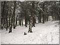
There are currently over 7.5m images from over14,400 individuals and you can help contribute to the project by visiting https://www.geograph.org.uk
Image Map
Images are licensed for reuse under creativecommons.org/licenses/by-sa/2.0
Notes
- Clicking on the map will re-center to the selected point.
- The higher the marker number, the further away the image location is from the centre of the postcode.
Image Listing (33 Images Found)
Images are licensed for reuse under creativecommons.org/licenses/by-sa/2.0
Image
Details
Distance
1
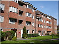
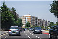
Lions Dene, The Deneway, Westdene
Lions Dene is a block of 37 flats owned by Brighton Lions Housing Society and let to senior citizens at affordable rents.
Image: © Brian Slater
Taken: 5 Apr 2009
0.02 miles
2
Entrance, Eldred Avenue Copse, Withdean
A small strip of woodland that lies between the railway and Eldred Avenue. Since 1997 it has been a local nature reserve looked after by the council and a local residents group alongside nearby Westdene Woods and Withdean Wood.
Image: © Simon Carey
Taken: 20 Jan 2013
0.04 miles
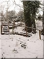
3
The Deneway Railway Bridge
Originally built as a farm bridge to allow Withdean Farm access to Newmans Barn and remained so until the 1950s. The Deneway is a residential road that links Eldred Avenue to London Road, the A23.
Image: © Simon Carey
Taken: 20 Jan 2013
0.05 miles
4
Eldred Avenue, Westdene
The road had been laid out in the early 1930s though the building of houses only slowly developed through that decade and mainly on the western side. Much of the rest, including the shops on the eastern side, was only added with the rest of the estate through the 1950s. The parade of shops includes the post office, a small general store, a butcher, delicatessen, pharmacy and Chinese takeaway.
Image: © Simon Carey
Taken: 20 Jan 2013
0.09 miles
5
Westdene Woods Nature Reserve
The eight acre wood was acquired by the council in 1939 and has been a local nature reserve since 1997 looked after by the council and a local residents group which also takes care of Withdean Woods and Eldred Avenue Copse.
Image: © Simon Carey
Taken: 20 Jan 2013
0.16 miles
6
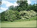
Lilacs in Withdean Park
Some of the Lilacs which the park is famous for
Image: © Paul Gillett
Taken: 16 Jun 2009
0.16 miles
7
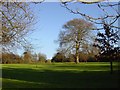
Withdean Park, looking east from the bottom
Image: © Brian Dungate
Taken: 9 Dec 2006
0.16 miles
8
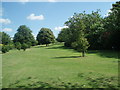
Withdean Park
As you enter the park from the London Road
Image: © Paul Gillett
Taken: 16 Jun 2009
0.17 miles
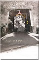
10
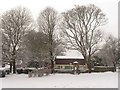
Wooden Pavilion, Westdene
Built as a home to the bowling clubs that used to use Image and now used as a local community centre. The flint walls that surround a small playground give a clue to its former use as a barn. Newmans Barn as it was known was once the only building located in the valley and initially survived the early development of the suburb during the 1930s but was finally knocked down in the early 1960s.
Image: © Simon Carey
Taken: 20 Jan 2013
0.18 miles