IMAGES TAKEN NEAR TO
Pemberton Close, LANCING, BN15 9RD
Introduction
This page details the photographs taken nearby to Pemberton Close, BN15 9RD by members of the Geograph project.
The Geograph project started in 2005 with the aim of publishing, organising and preserving representative images for every square kilometre of Great Britain, Ireland and the Isle of Man.

There are currently over 7.5m images from over14,400 individuals and you can help contribute to the project by visiting https://www.geograph.org.uk
Image Map
Images are licensed for reuse under creativecommons.org/licenses/by-sa/2.0
Notes
- Clicking on the map will re-center to the selected point.
- The higher the marker number, the further away the image location is from the centre of the postcode.
Image Listing (42 Images Found)
Images are licensed for reuse under creativecommons.org/licenses/by-sa/2.0
Image
Details
Distance
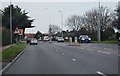
1
Roundabout, North Lancing
at the junction of Glebe Way, West Lane and Grover Avenue near the Upper Brighton Road
Image: © Paul Gillett
Taken: 27 Oct 2014
0.05 miles
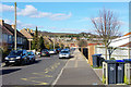
2
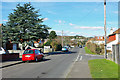
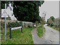
West Lane, Lancing
The high ground is beyond the A27, but West Lane does not now directly connect with this.
Image: © Robin Webster
Taken: 4 Mar 2010
0.07 miles
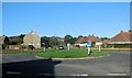
3
School Grounds, Globe Primary School
The Globe is an academy school in North Lancing http://www.theglobe.w-sussex.sch.uk/
Image: © Paul Gillett
Taken: 27 Oct 2014
0.09 miles
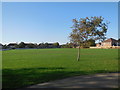
6
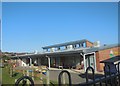
Globe Primary School
Academy School in Irene Avenue, North Lancing http://www.theglobe.w-sussex.sch.uk/
Image: © Paul Gillett
Taken: 27 Oct 2014
0.15 miles
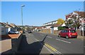
9
Looking southwards down Upper West Lane
Image: © Basher Eyre
Taken: 12 Mar 2011
0.18 miles
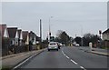
10
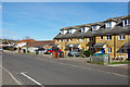
New development, Irene Avenue
A small row of newish houses, with a newish school beyond.
Image: © Robin Webster
Taken: 4 Mar 2010
0.18 miles