IMAGES TAKEN NEAR TO
Grand Avenue, LANCING, BN15 9QD
Introduction
This page details the photographs taken nearby to Grand Avenue, BN15 9QD by members of the Geograph project.
The Geograph project started in 2005 with the aim of publishing, organising and preserving representative images for every square kilometre of Great Britain, Ireland and the Isle of Man.

There are currently over 7.5m images from over14,400 individuals and you can help contribute to the project by visiting https://www.geograph.org.uk
Image Map
Images are licensed for reuse under creativecommons.org/licenses/by-sa/2.0
Notes
- Clicking on the map will re-center to the selected point.
- The higher the marker number, the further away the image location is from the centre of the postcode.
Image Listing (45 Images Found)
Images are licensed for reuse under creativecommons.org/licenses/by-sa/2.0
Image
Details
Distance
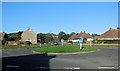
2
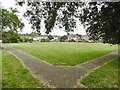
Lancing, Manor Park Gardens
Gardens between Brighton Road and First Avenue.
Image: © Mike Faherty
Taken: 18 May 2019
0.05 miles
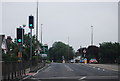
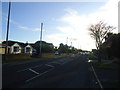
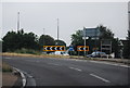
5
Roundabout, North Lancing
at the junction of Glebe Way, West Lane and Grover Avenue near the Upper Brighton Road
Image: © Paul Gillett
Taken: 27 Oct 2014
0.11 miles
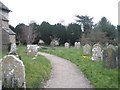
6
St James the Less
Lancing Parish Church situated North of the A27 and undergoing some refurbishment.
Image: © Chris Shaw
Taken: 14 Jun 2005
0.13 miles
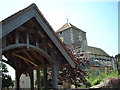
8
Church of St James the Less, North Lancing: church path
Image: © Basher Eyre
Taken: 12 Mar 2011
0.13 miles
10

St James the Less, North Lancing, West Sussex
Image: © nick macneill
Taken: 15 Nov 2010
0.14 miles