IMAGES TAKEN NEAR TO
Tower Road, LANCING, BN15 9JJ
Introduction
This page details the photographs taken nearby to Tower Road, BN15 9JJ by members of the Geograph project.
The Geograph project started in 2005 with the aim of publishing, organising and preserving representative images for every square kilometre of Great Britain, Ireland and the Isle of Man.

There are currently over 7.5m images from over14,400 individuals and you can help contribute to the project by visiting https://www.geograph.org.uk
Image Map
Images are licensed for reuse under creativecommons.org/licenses/by-sa/2.0
Notes
- Clicking on the map will re-center to the selected point.
- The higher the marker number, the further away the image location is from the centre of the postcode.
Image Listing (100 Images Found)
Images are licensed for reuse under creativecommons.org/licenses/by-sa/2.0
Image
Details
Distance
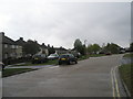
3
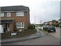
A rare sight in this election campaign
Taken in Tower Road, a Labour poster- for one Emily Benn: any relation of Tony or Hilary, one wonders....
Image: © Basher Eyre
Taken: 2 May 2010
0.01 miles
4
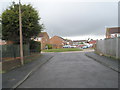
Looking from Hurstfield into Bushby Close
Image: © Basher Eyre
Taken: 2 May 2010
0.03 miles
8
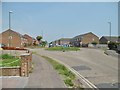
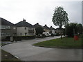
Lancing, roundabout
On Tower Road, at the junction with Leconfield Road; terraced housing on both sides.
Image: © Mike Faherty
Taken: 18 May 2019
0.04 miles