IMAGES TAKEN NEAR TO
Orchard Avenue, LANCING, BN15 9EB
Introduction
This page details the photographs taken nearby to Orchard Avenue, BN15 9EB by members of the Geograph project.
The Geograph project started in 2005 with the aim of publishing, organising and preserving representative images for every square kilometre of Great Britain, Ireland and the Isle of Man.

There are currently over 7.5m images from over14,400 individuals and you can help contribute to the project by visiting https://www.geograph.org.uk
Image Map
Images are licensed for reuse under creativecommons.org/licenses/by-sa/2.0
Notes
- Clicking on the map will re-center to the selected point.
- The higher the marker number, the further away the image location is from the centre of the postcode.
Image Listing (21 Images Found)
Images are licensed for reuse under creativecommons.org/licenses/by-sa/2.0
Image
Details
Distance
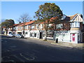
1
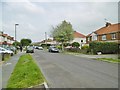
Lancing, First Avenue
Many of the roads between the current village centre and the historic village have numerical names - apparently from First to Eighth, with between-the-wars housing.
Image: © Mike Faherty
Taken: 18 May 2019
0.12 miles
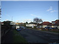
2
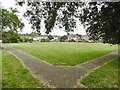
Lancing, Manor Park Gardens
Gardens between Brighton Road and First Avenue.
Image: © Mike Faherty
Taken: 18 May 2019
0.14 miles
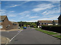
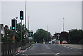
10
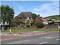
The Harvester
Corner of Grinstead Avenue & Grinstead Lane
Image: © Josie Campbell
Taken: 25 Jul 2011
0.19 miles