IMAGES TAKEN NEAR TO
Links Road, LANCING, BN15 9BY
Introduction
This page details the photographs taken nearby to Links Road, BN15 9BY by members of the Geograph project.
The Geograph project started in 2005 with the aim of publishing, organising and preserving representative images for every square kilometre of Great Britain, Ireland and the Isle of Man.

There are currently over 7.5m images from over14,400 individuals and you can help contribute to the project by visiting https://www.geograph.org.uk
Image Map
Images are licensed for reuse under creativecommons.org/licenses/by-sa/2.0
Notes
- Clicking on the map will re-center to the selected point.
- The higher the marker number, the further away the image location is from the centre of the postcode.
Image Listing (7 Images Found)
Images are licensed for reuse under creativecommons.org/licenses/by-sa/2.0
Image
Details
Distance

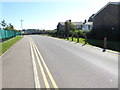
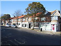
2
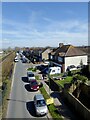
Freshbrook Road, Lancing
A residential road that links South Street to Old Salts Farm Road with the northern section running parallel to the railway. The road was originally built to provide access to a number of 19th century nurseries but was developed from the 1920s onwards and later bridged in the 1950s by the Grinstead Lane flyover where this view is taken.
Image: © Simon Carey
Taken: 31 Mar 2024
0.19 miles
3
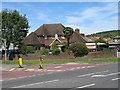
The Harvester
Corner of Grinstead Avenue & Grinstead Lane
Image: © Josie Campbell
Taken: 25 Jul 2011
0.20 miles