IMAGES TAKEN NEAR TO
Brighton Road, LANCING, BN15 8RP
Introduction
This page details the photographs taken nearby to Brighton Road, BN15 8RP by members of the Geograph project.
The Geograph project started in 2005 with the aim of publishing, organising and preserving representative images for every square kilometre of Great Britain, Ireland and the Isle of Man.

There are currently over 7.5m images from over14,400 individuals and you can help contribute to the project by visiting https://www.geograph.org.uk
Image Map
Images are licensed for reuse under creativecommons.org/licenses/by-sa/2.0
Notes
- Clicking on the map will re-center to the selected point.
- The higher the marker number, the further away the image location is from the centre of the postcode.
Image Listing (50 Images Found)
Images are licensed for reuse under creativecommons.org/licenses/by-sa/2.0
Image
Details
Distance
1
High Rise buildings on Brighton Road, South Lancing
Partially screened by this hedge of seaside plants - but they have a bit further to go, but hey, who would want to spoil the fabulous sea view from within!
Image: © Chris
Taken: 11 Jun 2016
0.02 miles
2
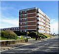
Francome House, Brighton Road, Lancing
The large block was built around the early 1970s. This view is from Western Road.
Image: © Simon Carey
Taken: 31 Mar 2024
0.03 miles
3
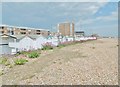
Lancing, beach huts
Between Brighton Road and Lancing Beach.
Image: © Mike Faherty
Taken: 25 May 2019
0.03 miles
4
Beach Huts and varied forms of locomotion along South Lancing seafront
Image: © Chris
Taken: 11 Jun 2016
0.03 miles
5
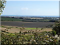
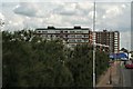
Looking southwards across fields from Charmandean Lane
I think the tower blocks in the centre of the picture must be in Lancing. Any corrections will be gratefully received.
Image: © Shazz
Taken: 26 Sep 2015
0.04 miles
6
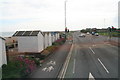
Beach huts next to Brighton Road, junction with Western Road, South Lancing
Image: © Chris
Taken: 11 Jun 2016
0.04 miles
7
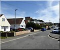
West End Way, Lancing
A cul de sac off Brighton Road, the A259, that originally ran through to Winston Road before being blocked.
Image: © Simon Carey
Taken: 31 Mar 2024
0.06 miles
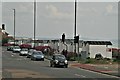
8
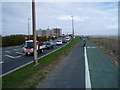
Worthing to Shoreham cycle path
The cycle path was completed this year and forms part of the almost traffic-free route between Worthing and Brighton. Here it runs parallel to the A259 Brighton Road often a point of serious congestion. The block of flats at the corner of Western Road, Lancing can be seen in the distance
Image: © Peter Holmes
Taken: 6 Nov 2007
0.07 miles
9
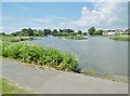
Worthing, lake
At Brooklands Park. Much of the park is inaccessible: renovation?
Image: © Mike Faherty
Taken: 25 May 2019
0.07 miles
10
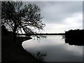
Brooklands Leisure Park: Lancing
This park is situated in the western half of the grid square. There is a model railway that tours the outskirts of the park and there are a variety of waterfowl around. This picture was taken looking towards the sea.
Image: © Pam Brophy
Taken: 15 Apr 2005
0.07 miles