IMAGES TAKEN NEAR TO
Brighton Road, LANCING, BN15 8RB
Introduction
This page details the photographs taken nearby to Brighton Road, BN15 8RB by members of the Geograph project.
The Geograph project started in 2005 with the aim of publishing, organising and preserving representative images for every square kilometre of Great Britain, Ireland and the Isle of Man.

There are currently over 7.5m images from over14,400 individuals and you can help contribute to the project by visiting https://www.geograph.org.uk
Image Map
Images are licensed for reuse under creativecommons.org/licenses/by-sa/2.0
Notes
- Clicking on the map will re-center to the selected point.
- The higher the marker number, the further away the image location is from the centre of the postcode.
Image Listing (112 Images Found)
Images are licensed for reuse under creativecommons.org/licenses/by-sa/2.0
Image
Details
Distance
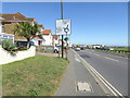
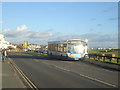
3
Junction of Chester Avenue with Brighton Road
Image: © Shazz
Taken: 11 Sep 2016
0.03 miles
4
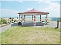
Lancing, pavilion
In Beach Green, overlooking Lancing Beach; commemorating those fallen in WWI.
Image: © Mike Faherty
Taken: 25 May 2019
0.04 miles
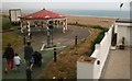
7
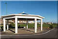
Shelter, Beach Green
Shelter at the western end of Beach Green.
Image: © Ian Capper
Taken: 26 Dec 2013
0.05 miles
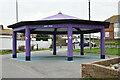
8
Gaily painted shelter at the end of Beach Green, South Lancing
Image: © Chris
Taken: 11 Jun 2016
0.05 miles