IMAGES TAKEN NEAR TO
Burrell Avenue, LANCING, BN15 8QB
Introduction
This page details the photographs taken nearby to Burrell Avenue, BN15 8QB by members of the Geograph project.
The Geograph project started in 2005 with the aim of publishing, organising and preserving representative images for every square kilometre of Great Britain, Ireland and the Isle of Man.

There are currently over 7.5m images from over14,400 individuals and you can help contribute to the project by visiting https://www.geograph.org.uk
Image Map
Images are licensed for reuse under creativecommons.org/licenses/by-sa/2.0
Notes
- Clicking on the map will re-center to the selected point.
- The higher the marker number, the further away the image location is from the centre of the postcode.
Image Listing (113 Images Found)
Images are licensed for reuse under creativecommons.org/licenses/by-sa/2.0
Image
Details
Distance
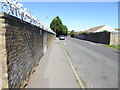
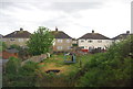
1
Norton Road, Lancing
A cul de sac off Elm Grove built in the 1970s.
Image: © Simon Carey
Taken: 31 Mar 2024
0.01 miles
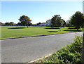
4
Elm Grove Park, Lancing
An open space and play area on the eastern side of Elm Grove.
Image: © Simon Carey
Taken: 31 Mar 2024
0.07 miles
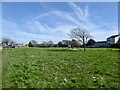
5
Open land with play area and seating by Elm Grove
Image: © Shazz
Taken: 11 Sep 2016
0.09 miles
7
Semi detached houses on Tower Rd, Sompting
Image: © N Chadwick
Taken: 8 May 2011
0.10 miles
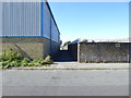
8
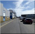
Chartwell Road, Lancing Business Park, Lancing
Originally known as the Churchill Industrial Estate it was opened in the mid 1960s on the site of the former Lancing Carriage Works.
Image: © Simon Carey
Taken: 31 Mar 2024
0.11 miles