IMAGES TAKEN NEAR TO
The Saltings, LANCING, BN15 8EH
Introduction
This page details the photographs taken nearby to The Saltings, BN15 8EH by members of the Geograph project.
The Geograph project started in 2005 with the aim of publishing, organising and preserving representative images for every square kilometre of Great Britain, Ireland and the Isle of Man.

There are currently over 7.5m images from over14,400 individuals and you can help contribute to the project by visiting https://www.geograph.org.uk
Image Map
Images are licensed for reuse under creativecommons.org/licenses/by-sa/2.0
Notes
- Clicking on the map will re-center to the selected point.
- The higher the marker number, the further away the image location is from the centre of the postcode.
Image Listing (50 Images Found)
Images are licensed for reuse under creativecommons.org/licenses/by-sa/2.0
Image
Details
Distance
1
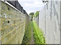
Lancing, footpath
Between house backs, from Old Salts Farm Road to Kings Road.
Image: © Mike Faherty
Taken: 1 Jun 2019
0.06 miles
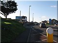
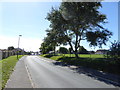
3
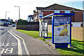
Brighton Road - Old Salts Farm Road bus stop
On A259 Brighton Road towards Shoreham and Brighton.
Image: © Robin Webster
Taken: 4 Mar 2010
0.09 miles
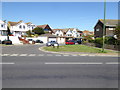
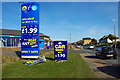
4
Car care on Brighton Road
See http://www.geograph.org.uk/photo/1736260 from 2010.
Image: © Shazz
Taken: 11 Sep 2016
0.10 miles
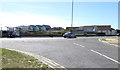
5
Brighton Road South Lancing
The slip road on the left leads to Beach Park and their Leisure Homes
Image: © Dave Spicer
Taken: 29 Nov 2012
0.10 miles
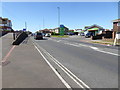
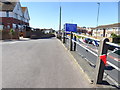
7
Junction of Old Salts Farm and Brighton Roads with bus stop
Image: © Shazz
Taken: 11 Sep 2016
0.10 miles
10
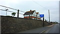
Entrance to Beach Park Caravan Park, Lancing
Image: © Richard Cooke
Taken: 5 Jun 2018
0.11 miles