IMAGES TAKEN NEAR TO
Alma Street, LANCING, BN15 8BA
Introduction
This page details the photographs taken nearby to Alma Street, BN15 8BA by members of the Geograph project.
The Geograph project started in 2005 with the aim of publishing, organising and preserving representative images for every square kilometre of Great Britain, Ireland and the Isle of Man.

There are currently over 7.5m images from over14,400 individuals and you can help contribute to the project by visiting https://www.geograph.org.uk
Image Map (Loading...)


Getting Data...Please wait
Leaflet Map data © OpenStreetMap
Images are licensed for reuse under creativecommons.org/licenses/by-sa/2.0
Notes
- Clicking on the map will re-center to the selected point.
- The higher the marker number, the further away the image location is from the centre of the postcode.
Image Listing (143 Images Found)
Images are licensed for reuse under creativecommons.org/licenses/by-sa/2.0
Image
Details
Distance
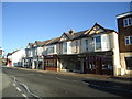
3
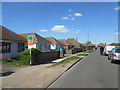
Cecil Road BN15 8HP
Typical bungalows for this area.
Image: © Peter Holmes
Taken: 18 Apr 2015
0.04 miles
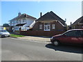
4
Lancing, Chesham House
Community centre on South Street, operated by RVS, with attached tea room. https://cheshamhouse.wordpress.com/about/
Image: © Mike Faherty
Taken: 25 May 2019
0.04 miles
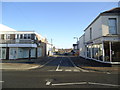
5
Lancing and Sompting Lions Community Hall
Roberts Road BN15 8AR.
Image: © Peter Holmes
Taken: 18 Apr 2015
0.04 miles
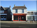
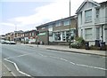
8
Parade of shops, South Street, Lancing
Image: © Stacey Harris
Taken: 17 Dec 2011
0.06 miles