IMAGES TAKEN NEAR TO
Coombes, LANCING, BN15 0RS
Introduction
This page details the photographs taken nearby to BN15 0RS by members of the Geograph project.
The Geograph project started in 2005 with the aim of publishing, organising and preserving representative images for every square kilometre of Great Britain, Ireland and the Isle of Man.

There are currently over 7.5m images from over14,400 individuals and you can help contribute to the project by visiting https://www.geograph.org.uk
Image Map
Images are licensed for reuse under creativecommons.org/licenses/by-sa/2.0
Notes
- Clicking on the map will re-center to the selected point.
- The higher the marker number, the further away the image location is from the centre of the postcode.
Image Listing (129 Images Found)
Images are licensed for reuse under creativecommons.org/licenses/by-sa/2.0
Image
Details
Distance
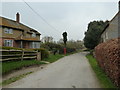
1
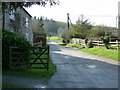
Bridleway and entrance to Church Farm, Coombes
Church Farm have their own website which includes information about the Saxon church and life over five generations of farming http://www.coombes.co.uk
Image: © Dave Spicer
Taken: 12 Feb 2011
0.00 miles
2
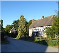
Church Farm, Coombes
The farmhouse dates from the 16th century with a 19th century extension.
Image: © Simon Carey
Taken: 1 Jun 2020
0.00 miles
3
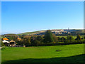
Coombes
Viewed from the edge of Coombes Copse. The village street once travelled up to the church, out of shot on the left, and also had a number of tracks heading south from it. Neither remain today, the church is reached via a bridleway or footpath and the tracks along with any dwellings have long since reverted to pasture. Beyond the village is the Adur flood plain with Beeding Cement Works over the far side of the valley.
Image: © Simon Carey
Taken: 18 Oct 2008
0.01 miles
4

Coombes from Above
Showing the dry valley from which it derived its name. The scaffolding covering the church roof is on the right with the small village street running beyond it. Much of the rest of the village is taken up by the buildings of Church Farm which is a working farm that also offers farm tours for visitors of any age. Beyond that is Passies Pond which also belongs to the farm and was dug out in the early 1990s to provide angling facilities, the water in view is the match canal with a further angling lake beyond obscured by the trees.
http://www.coombes.co.uk/
Image: © Simon Carey
Taken: 18 Oct 2008
0.01 miles
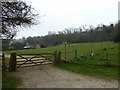
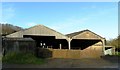
6

Coombes Village Street
Near enough the entire village can be found down this track which little more than a farm drive and bridleway with the road from Steyning to Lancing passing at the bottom of the track. The building in view is I believe Coombes Farmhouse that was built in the 17th century. There are three more cottages down this track towards the road.
Image: © Simon Carey
Taken: 18 Oct 2008
0.01 miles
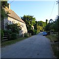
7
Looking from Coombes Farm down to the telephone box
Image: © Basher Eyre
Taken: 12 Mar 2011
0.01 miles
9
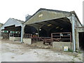
Moove on pal, you're blocking our view
Cows at Coombes Farm.
Image: © Basher Eyre
Taken: 12 Mar 2011
0.02 miles
10
Ox Brook Cottage, Coombes
Located to the immediate east of Church Farmhouse and dating from the 18th century.
Image: © Simon Carey
Taken: 1 Jun 2020
0.02 miles