IMAGES TAKEN NEAR TO
Mount Way, LANCING, BN15 0QD
Introduction
This page details the photographs taken nearby to Mount Way, BN15 0QD by members of the Geograph project.
The Geograph project started in 2005 with the aim of publishing, organising and preserving representative images for every square kilometre of Great Britain, Ireland and the Isle of Man.

There are currently over 7.5m images from over14,400 individuals and you can help contribute to the project by visiting https://www.geograph.org.uk
Image Map (Loading...)


Getting Data...Please wait
Leaflet Map data © OpenStreetMap
Images are licensed for reuse under creativecommons.org/licenses/by-sa/2.0
Notes
- Clicking on the map will re-center to the selected point.
- The higher the marker number, the further away the image location is from the centre of the postcode.
Image Listing (11 Images Found)
Images are licensed for reuse under creativecommons.org/licenses/by-sa/2.0
Image
Details
Distance
1
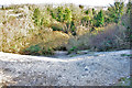
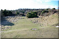
Chalky slope, old chalk pit, 2010
Probably a safety conversion from a cliff, the pit area is popular with the public.
Image: © Robin Webster
Taken: 4 Mar 2010
0.09 miles
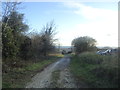
4
Footpath crosses enclosure in small valley to junction with bridleway
Image: © Shazz
Taken: 11 Sep 2016
0.10 miles
5
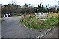
Lancing Ring Car Park
Car Park for Lancing Ring the Local Nature Reserve
Image: © Bob Parkes
Taken: 16 Nov 2007
0.11 miles
6
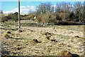
Ant hills
There is a ruined building in the bushes beyond.
Image: © Robin Webster
Taken: 4 Mar 2010
0.11 miles
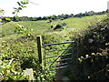
8

Footpath to Lancing Ring Nature Reserve
The reserve is at the far end of the field. The footpath has come from Coombes.
Image: © Simon Carey
Taken: 18 Oct 2008
0.13 miles
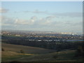
9
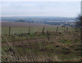
View east near Lancing Ring
Towards Brighton in the distance, on a dull January afternoon.
Image: © Andrew Hill
Taken: 27 Jan 2009
0.22 miles
10
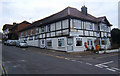
Village shop and post office, now closed
Image: © Andrew Hill
Taken: 27 Jan 2009
0.23 miles