IMAGES TAKEN NEAR TO
Firle Road, LANCING, BN15 0NZ
Introduction
This page details the photographs taken nearby to Firle Road, BN15 0NZ by members of the Geograph project.
The Geograph project started in 2005 with the aim of publishing, organising and preserving representative images for every square kilometre of Great Britain, Ireland and the Isle of Man.

There are currently over 7.5m images from over14,400 individuals and you can help contribute to the project by visiting https://www.geograph.org.uk
Image Map
Images are licensed for reuse under creativecommons.org/licenses/by-sa/2.0
Notes
- Clicking on the map will re-center to the selected point.
- The higher the marker number, the further away the image location is from the centre of the postcode.
Image Listing (11 Images Found)
Images are licensed for reuse under creativecommons.org/licenses/by-sa/2.0
Image
Details
Distance
4
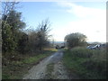
Cokeham Tenantry
The name of the field according to Sompting's 1840 tithe map that is now part of Lancing Ring nature reserve.
Image: © Simon Carey
Taken: 12 Jul 2020
0.19 miles
7
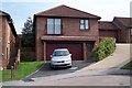
Sompting, West Sussex
Typical house on the estate north of the A24 between Sompting and North Lancing.
Image: © Brendan and Ruth McCartney
Taken: 15 Sep 2006
0.22 miles
8
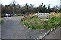
Lancing Ring Car Park
Car Park for Lancing Ring the Local Nature Reserve
Image: © Bob Parkes
Taken: 16 Nov 2007
0.23 miles
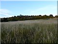
10
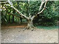
Lancing Ring Nature Reserve
Following the public footpath through the wooded part of the reserve.
Image: © Simon Carey
Taken: 12 Jul 2020
0.24 miles