IMAGES TAKEN NEAR TO
Blacksmiths Crescent, LANCING, BN15 0BF
Introduction
This page details the photographs taken nearby to Blacksmiths Crescent, BN15 0BF by members of the Geograph project.
The Geograph project started in 2005 with the aim of publishing, organising and preserving representative images for every square kilometre of Great Britain, Ireland and the Isle of Man.

There are currently over 7.5m images from over14,400 individuals and you can help contribute to the project by visiting https://www.geograph.org.uk
Image Map
Images are licensed for reuse under creativecommons.org/licenses/by-sa/2.0
Notes
- Clicking on the map will re-center to the selected point.
- The higher the marker number, the further away the image location is from the centre of the postcode.
Image Listing (138 Images Found)
Images are licensed for reuse under creativecommons.org/licenses/by-sa/2.0
Image
Details
Distance
1
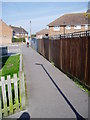
Twitten at Templars Mews
Footpath 2070 linking Test Road and Blacksmiths Crescent.
Image: © Peter Holmes
Taken: 13 Apr 2010
0.02 miles
3
Footpath 2070 crossing Test Road
Twitten to Templars Mews.
Image: © Peter Holmes
Taken: 13 Apr 2010
0.03 miles
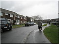
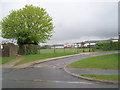
5
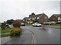
Approaching the junction of Test Road and Sylvan Road
Image: © Basher Eyre
Taken: 2 May 2010
0.05 miles
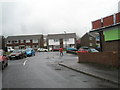
6
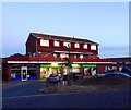
Co-op, Hamble Road, Sompting
Shared with a fish and chip shop on the ground floor whilst above is Hamble Court. Viewed at dusk.
Image: © Simon Carey
Taken: 22 Jul 2020
0.05 miles
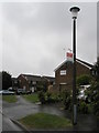
8
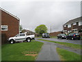
Approaching the junction of Hamble Road and May Tree Close
Image: © Basher Eyre
Taken: 2 May 2010
0.05 miles
9
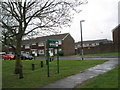
Looking from Test Road towards the Sompting Village Primary School
Image: © Basher Eyre
Taken: 2 May 2010
0.05 miles
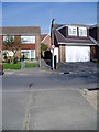
10
Approaching the junction of Hamble Road and Test Road
Image: © Basher Eyre
Taken: 2 May 2010
0.06 miles