IMAGES TAKEN NEAR TO
West Street, LANCING, BN15 0AX
Introduction
This page details the photographs taken nearby to West Street, BN15 0AX by members of the Geograph project.
The Geograph project started in 2005 with the aim of publishing, organising and preserving representative images for every square kilometre of Great Britain, Ireland and the Isle of Man.

There are currently over 7.5m images from over14,400 individuals and you can help contribute to the project by visiting https://www.geograph.org.uk
Image Map
Images are licensed for reuse under creativecommons.org/licenses/by-sa/2.0
Notes
- Clicking on the map will re-center to the selected point.
- The higher the marker number, the further away the image location is from the centre of the postcode.
Image Listing (36 Images Found)
Images are licensed for reuse under creativecommons.org/licenses/by-sa/2.0
Image
Details
Distance
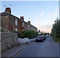
1
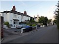
3-6, Rooksacre Cottages, West Street, Sompting
Actually just three dwellings now as numbers 3 and 4 have been combined into one. Numbers 1 and 2 are located behind Westcroft away from the street. Dating from the mid to late 19th century.
Image: © Simon Carey
Taken: 22 Jul 2020
0.01 miles
2
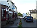
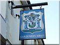
Looking west on West Street at the "Gardeners Arms" PH
Image: © Shazz
Taken: 26 Sep 2015
0.02 miles
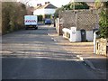
3
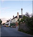
The Gardeners Arms, West Street, Sompting
In use as a public house since at least the 1870s until 2008 when it closed. However, it was reopened a year later and is still going strong today.
Image: © Simon Carey
Taken: 22 Jul 2020
0.03 miles
5
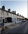
Latimers Cottages/Edwards Terrace, West Street, Sompting
A row of nine terraced cottages built in the first decade of the 20th century. Latimers Cottages are the three to the left whilst Edwards Terrace are the remaining six to the right
Image: © Simon Carey
Taken: 22 Jul 2020
0.05 miles
7
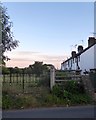
Burry Cottages, West Street, Sompting
Built in the mid 19th century for labourers working in the local market gardens and nurseries.
Image: © Simon Carey
Taken: 22 Jul 2020
0.07 miles
8
Western Terrace, West Street, Sompting
Built in the first decade of the 20th century to house the workers needed for the nearby nurseries.
Image: © Simon Carey
Taken: 22 Jul 2020
0.07 miles
9
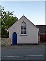
Hall, West Street, Sompting
Originally built in 1887 as a Methodist Chapel and later used by the Salvation Army. Not sure who uses it today.
Image: © Simon Carey
Taken: 22 Jul 2020
0.07 miles
10
Alishaan Indian Restaurant, West Street, Sompting
Originally a public house called the Brewers Arms, then for many years a tearoom and restaurant known as The Smugglers. Currently serving Indian cuisine.
Image: © Simon Carey
Taken: 22 Jul 2020
0.08 miles