IMAGES TAKEN NEAR TO
York Place, BRIGHTON, BN1 4LG
Introduction
This page details the photographs taken nearby to York Place, BN1 4LG by members of the Geograph project.
The Geograph project started in 2005 with the aim of publishing, organising and preserving representative images for every square kilometre of Great Britain, Ireland and the Isle of Man.

There are currently over 7.5m images from over14,400 individuals and you can help contribute to the project by visiting https://www.geograph.org.uk
Image Map
Images are licensed for reuse under creativecommons.org/licenses/by-sa/2.0
Notes
- Clicking on the map will re-center to the selected point.
- The higher the marker number, the further away the image location is from the centre of the postcode.
Image Listing (904 Images Found)
Images are licensed for reuse under creativecommons.org/licenses/by-sa/2.0
Image
Details
Distance
1
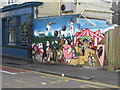
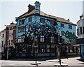
Graffiti, The Hobgoblin pub
This unusual graffiti is alongside the pub garden at Cheapside, Brighton.
Image: © Peter Whitcomb
Taken: 22 Jan 2012
0.02 miles
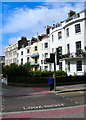
3
Hobgoblin
Public house at York Place, Brighton.
Image: © Peter Trimming
Taken: 16 Jun 2021
0.02 miles
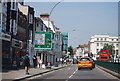
4
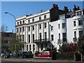
St Peters Place
Head east down Cheapside then the same direction along St Peters Place until the junction with Ditchling Road. The terrace was built in 1820 at the northern extreme of the open land from the Steine and designed by Amon and Amon Henry Wilds. Part of them are now used by Brighton Council.
Click on the link to take you to the next page. http://www.geograph.org.uk/photo/231363
Image: © Simon Carey
Taken: 1 Sep 2006
0.03 miles
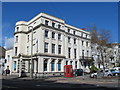
7
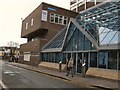
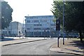
City College
City College Brighton & Hove (CCB) is a large general further education college. Its main campus is at Pelham Street, Brighton. It was formerly known as Brighton College of Technology and before that Brighton Technical College.
College Web site: http://www.ccb.ac.uk/
Image: © Paul Gillett
Taken: 27 Feb 2010
0.04 miles
8
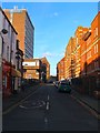
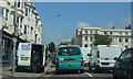
Pelham Street, Brighton
A former residential street linking Trafalgar Street to Cheapside that was developed between 1820-45. Only a few original houses survive and these are to the left in the foreground. The rest of the western side was removed in the 1960s to make way for the Technical College now known as City College. The eastern side initially contained large gardens for houses in York Place which were replaced to the south by York Place Elementary School which was expanded in 1884 to cover the entire eastern side of the street becoming the York Place Secondary School with separate sections for girls and boys. This school moved to a new site at Varndean in 1926 (Girls) and 1931 (Boys) after which the school became the Fawcett School for boys and Margaret Hardy School for girls. These too moved to a new site at Patcham in the mid 1960s and the buildings were taken over by the Technical College which still uses them today.
Image: © Simon Carey
Taken: 21 Nov 2015
0.04 miles