IMAGES TAKEN NEAR TO
Rosehill Terrace Mews, BRIGHTON, BN1 4HH
Introduction
This page details the photographs taken nearby to Rosehill Terrace Mews, BN1 4HH by members of the Geograph project.
The Geograph project started in 2005 with the aim of publishing, organising and preserving representative images for every square kilometre of Great Britain, Ireland and the Isle of Man.

There are currently over 7.5m images from over14,400 individuals and you can help contribute to the project by visiting https://www.geograph.org.uk
Image Map
Images are licensed for reuse under creativecommons.org/licenses/by-sa/2.0
Notes
- Clicking on the map will re-center to the selected point.
- The higher the marker number, the further away the image location is from the centre of the postcode.
Image Listing (453 Images Found)
Images are licensed for reuse under creativecommons.org/licenses/by-sa/2.0
Image
Details
Distance
1
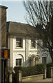
87 London Road, Brighton
Regency period survivor in a busy shopping street. Grade II listed.
Image: © Jim Osley
Taken: 13 Feb 2017
0.01 miles
2
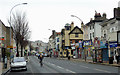
London Road, Brighton
This is the A23 south-east of Preston Circus crossroads.
Image: © Roger D Kidd
Taken: 1 Jan 2015
0.02 miles
3
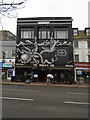
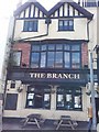
The Worlds End Pub, Brighton
On the London Road near Preston Circus, famous for its BBQ burgers etc https://www.theguardian.com/lifeandstyle/2011/jul/24/jay-rayner-restaurants-bbq-shack
Image: © Paul Gillett
Taken: 1 Mar 2017
0.03 miles
4
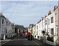
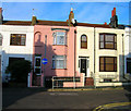
Rose Hill Terrace, Brighton
The road was developed in the early 1850s and originally linked London Road to Ditchling Road. However, bomb damage during the Second World War removed numbers 84-88 on whose site Rose Hill Court was erected in the 1980s effectively splitting the road in two with the eastern section now Image The high rise block in the distance is Vantage Point.
Image: © Simon Carey
Taken: 25 Oct 2015
0.03 miles
5
Rose Hill Terrace
Opposite the junction with London Terrace.
Image: © Simon Carey
Taken: 5 Nov 2006
0.03 miles
6
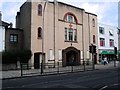
Former London Road Methodist Church
This church was erected in 1894 and designed by James Weir (F.R.I.B.A) of London, originally in red brick. The chapel opened on 21st February 1895. In 1910 the building was extended forward and a new Renaissance facade and a low tower on the north side of the pediment were added. The Church was closed in 2006
Image: © Paul Gillett
Taken: 17 Jan 2013
0.03 miles
8
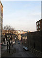
York Hill
Viewed from New England Street which it once joined but was redeveloped in the 1960s and is now a service road for New England House, built in 1962, on the left. Mayflower Court to the right is built on top of small multi-storey car park. The road running left-right as the crossroads is Elder Place to the left and Providence Place to the right. York Hill ends at the junction with London Road.
Image: © Simon Carey
Taken: 11 Jan 2009
0.04 miles
9
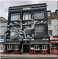
The World's End at Brighton
A public house on London Road.
Image: © Mat Fascione
Taken: 18 Apr 2023
0.05 miles
10
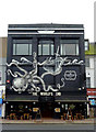
The World's End in Brighton
What a distinctive pub frontage!! Black, with a superb mural of an octopus attacking mariners, and references to Tennyson's formidable Kraken!! Apparently the mural, which wraps round the side of the building, took local artists less than a week to do in 2014.
Image: © Roger D Kidd
Taken: 1 Jan 2015
0.05 miles