IMAGES TAKEN NEAR TO
Fleet Street, BRIGHTON, BN1 4GS
Introduction
This page details the photographs taken nearby to Fleet Street, BN1 4GS by members of the Geograph project.
The Geograph project started in 2005 with the aim of publishing, organising and preserving representative images for every square kilometre of Great Britain, Ireland and the Isle of Man.

There are currently over 7.5m images from over14,400 individuals and you can help contribute to the project by visiting https://www.geograph.org.uk
Image Map
Images are licensed for reuse under creativecommons.org/licenses/by-sa/2.0
Notes
- Clicking on the map will re-center to the selected point.
- The higher the marker number, the further away the image location is from the centre of the postcode.
Image Listing (875 Images Found)
Images are licensed for reuse under creativecommons.org/licenses/by-sa/2.0
Image
Details
Distance
1
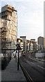
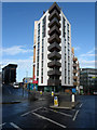
New England Quarter
View from Stroudley Road into the current redevelopment of the former locomotive works and goods yard. The unfinished building to the left will be known as One Brighton and will be ecologically friendly flats available for key workers. Beyond the junction of Stroudley Road and Fleet Street are flats from the area known as Block B whilst in the background is Theobald House opened in 1966.
Image: © Simon Carey
Taken: 11 Jan 2009
0.01 miles
2

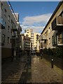
Walkway, New England Quarter
Separating Block C (right) from Block B (left) and linking Fleet Street with New England Street.
Image: © Simon Carey
Taken: 11 Jan 2009
0.02 miles
3
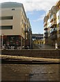
Kingscote Way
The name of the walkway that separates the two parts of block C in the New England Quarter, a recent development constructed on the site of the former locomotive works and goods yard.
Image: © Simon Carey
Taken: 25 Nov 2009
0.02 miles
4
Fenchurch Way
Pedestrian walkway connecting New England Street with Fleet Street within the New England Quarter, a recent development constructed on the site of the former locomotive works and goods yard. As it climbs the steps it crosses Kingscote Way another walkway which runs north-south. This area also has some commercial activity with a Sainsbury's out of shot to the right, a Japanese grocery store and Subway to the left out of shot and the Paris cafe bar in view. Brighton station can just be seen beyond the end of the walkway.
Image: © Simon Carey
Taken: 25 Nov 2009
0.02 miles


7

New Buildings near Brighton Station
See also Image
Image: © Julian P Guffogg
Taken: 10 May 2011
0.02 miles
8
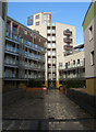
Block D, New England Quarter
The rear of the new development built on the site of the former locomotive works and goods yard. This is the end of Kingscote Way a pedestrianised street that begins on Cheapside.
Image: © Simon Carey
Taken: 25 Nov 2009
0.02 miles
9
Block E, New England Quarter
Located at the junction of Fleety Street and Stroudley Road. The new development was built on the site of the former locomotive works and goods yard. The former was built on pillars on the side of the hill whilst the latter was lower down nearer the station. The drop in Stroudley Road on the left marks the point where the former locomotive works begins whilst the blocks here are built in the grounds of the former goods yard.
Image: © Simon Carey
Taken: 25 Nov 2009
0.02 miles
