
IMAGES TAKEN NEAR TO
Kensington Place, BRIGHTON, BN1 4EJ
Introduction
This page details the photographs taken nearby to Kensington Place, BN1 4EJ by members of the Geograph project.
The Geograph project started in 2005 with the aim of publishing, organising and preserving representative images for every square kilometre of Great Britain, Ireland and the Isle of Man.

There are currently over 7.5m images from over14,400 individuals and you can help contribute to the project by visiting https://www.geograph.org.uk
Image Map
Images are licensed for reuse under creativecommons.org/licenses/by-sa/2.0
Notes
- Clicking on the map will re-center to the selected point.
- The higher the marker number, the further away the image location is from the centre of the postcode.
Image Listing (1257 Images Found)
Images are licensed for reuse under creativecommons.org/licenses/by-sa/2.0
Image
Details
Distance
1

Kensington Place
A side street that links Trafalgar Street to Gloucester Road taken at dusk. The western side was built in the 1820s whilst the eastern side was completed a decade later. The differing nature of both sides is down to building practices at the time whereby a developer would buy up plots build one or two houses then sell the plots on to others to build their own houses the result is a mix of imposing three story town houses which dwarf the smaller cottages which can often found either side of it. In stark contrast the eastern side was built as one long terrace which gives that side greater uniformity.
Image: © Simon Carey
Taken: 7 Oct 2011
0.01 miles
2

Tidy Street
Residential street linking Gloucester Road to Trafalgar Street. Theobald House is the tower block in the distance.
Image: © Simon Carey
Taken: 25 Nov 2009
0.01 miles

4

Kensington Place, Brighton
A residential street developed in the late 1820s or early 1830s. The architectural differences are due to the nature of the 19th century building in Brighton. This was once part of Third Furlong within the larger North Laine field. The furlong was divided into strips called Paul Pieces which were owned by a variety of people. When the town expanded northwards developers would purchase the strips in twos or threes which would be enough to build a road and houses either side. If there was not enough capital to do this then single strips were bought and one side built, or developers joined forces. Even then many builders would lease out plots within their strip. Subsequently on the eastern side of Kensington place there is an entire terrace built by one builder, on the western side a hodge podge of two and three storey houses built by a number of different ones. The large block of flats at the far end is Theobald House.
Image: © Simon Carey
Taken: 4 Oct 2015
0.01 miles

6

Guttersnipes, Gloucester Road
Small clothes shop on the junction of Gloucester Road and Trafalgar Lane.
Image: © Simon Carey
Taken: 21 Nov 2008
0.02 miles
7

Street Art by Puffin Club
In Trafalgar Lane.
Image: © Oliver Dixon
Taken: 11 Sep 2019
0.02 miles
8
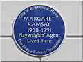
Blue plaque re Margaret Ramsey, Kensington Place, BN1
The location of this blue plaque is shown in Image
Image: © Mike Quinn
Taken: 20 Apr 2012
0.02 miles
9

Redcross Street
Head south down Whitecross Street then east into the car park. This is the remains of Redcross Street pulled down in the 1960s part of which became Pelham Tower and the rest a car park for the college. The building with the scaffolding in front of it is a former garage now Trafalgar Mews. It retains its original 1920s frontage and was still a working garage into the 1980s before becoming a private parking area then being rebuilt as mews residences.
Click on the link to take you to the next page. http://www.geograph.org.uk/photo/231160
Image: © Simon Carey
Taken: 1 Sep 2006
0.02 miles
10

Brighton: Trafalgar Street
Most of the shops down Trafalgar Street probably merit a photograph for one reason or another.
Here, on the right, at 18 Trafalgar Street, is the former shop of J Barker, who called himself or herself, in the two tablets either side of their name, as a 'dispensing chemist' but more interestingly as a 'paractical phrenologist'. Today the shop is occupied by 'trafagars' barber shop complete with the traditional red and white striped sign.
On the left, at 16 Trafalgar Street, is the 'Grand parade' garage with a gated opening to Trafalgar Mews.
Image: © Nigel Cox
Taken: 8 Jun 2008
0.02 miles