IMAGES TAKEN NEAR TO
Offington Lane, WORTHING, BN14 9RG
Introduction
This page details the photographs taken nearby to Offington Lane, BN14 9RG by members of the Geograph project.
The Geograph project started in 2005 with the aim of publishing, organising and preserving representative images for every square kilometre of Great Britain, Ireland and the Isle of Man.

There are currently over 7.5m images from over14,400 individuals and you can help contribute to the project by visiting https://www.geograph.org.uk
Image Map
Images are licensed for reuse under creativecommons.org/licenses/by-sa/2.0
Notes
- Clicking on the map will re-center to the selected point.
- The higher the marker number, the further away the image location is from the centre of the postcode.
Image Listing (7 Images Found)
Images are licensed for reuse under creativecommons.org/licenses/by-sa/2.0
Image
Details
Distance
2
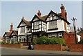
Offington Park Club, Hall Avenue, Worthing
Situated at junction of Hall Avenue and Offington Avenue this historic building was originally associated with Offington Hall.
Image: © Peter Holmes
Taken: 9 Jan 2008
0.15 miles
4
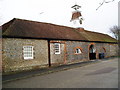
Stable Mews, Hall Avenue, Worthing
Formerly Offington Hall Riding School, a listed building and part of historic buildings associated with Offington Hall.
Image: © Peter Holmes
Taken: 9 Jan 2008
0.17 miles
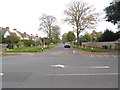
5
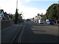
A road junction in Worthing
The junction is known as the Thomas A Becket as the Thomas A Becket pub is on one corner.
Image: © Dave Spicer
Taken: 3 Dec 2012
0.20 miles
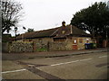
6

Thomas A'Becket, Rectory Road, Tarring
A popular local and large 1930's roadhouse situated at Poulters Corner, a busy crossroads between Littlehampton Road/Poulters Lane (A2032) and Rectory Road/Offington Lane (A2031).
Image: © Peter Holmes
Taken: 9 Jan 2008
0.21 miles