IMAGES TAKEN NEAR TO
Charmandean Road, WORTHING, BN14 9NA
Introduction
This page details the photographs taken nearby to Charmandean Road, BN14 9NA by members of the Geograph project.
The Geograph project started in 2005 with the aim of publishing, organising and preserving representative images for every square kilometre of Great Britain, Ireland and the Isle of Man.

There are currently over 7.5m images from over14,400 individuals and you can help contribute to the project by visiting https://www.geograph.org.uk
Image Map
Images are licensed for reuse under creativecommons.org/licenses/by-sa/2.0
Notes
- Clicking on the map will re-center to the selected point.
- The higher the marker number, the further away the image location is from the centre of the postcode.
Image Listing (13 Images Found)
Images are licensed for reuse under creativecommons.org/licenses/by-sa/2.0
Image
Details
Distance
1
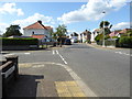
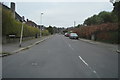
Looking westwards from Leigh Road into Charmandean Road
Image: © Shazz
Taken: 26 Sep 2015
0.01 miles
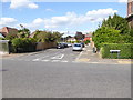
4
Sompting Road BN14 9EU
At junction with Hadley Avenue.
Image: © Peter Holmes
Taken: 28 Apr 2015
0.18 miles
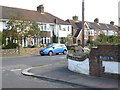
5
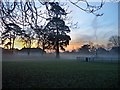
Playground in Sompting Road, Broadwater
This picture was taken at sunrise from the bank outside no 91
Image: © Linnet
Taken: 22 Dec 2005
0.20 miles
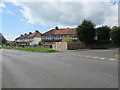
6
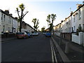
Southfield Road Broadwater Worthing
Now a cul-de-sac accessible from the west.
Image: © Dave Spicer
Taken: 29 Nov 2012
0.22 miles
7
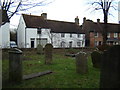
The old bakery in Broadwater Street East
18th century cottages. The white cottage was formerly Swifts, copyhold Broadwater Manor. The first baker from the 1860's onwards was William Manwaring, then the Knight family 1910-49.
Image: © Leigh Lawson
Taken: 2 Jan 2006
0.22 miles
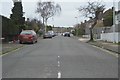
10
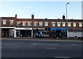
1-4, Downlands Parade, Upper Brighton Road, Broadwater, Worthing
The parade was built in the late 1940s or early 1950s and is located at the junction with Sompting Road.
Image: © Simon Carey
Taken: 22 Jul 2020
0.23 miles