IMAGES TAKEN NEAR TO
Southfield Road, WORTHING, BN14 9EQ
Introduction
This page details the photographs taken nearby to Southfield Road, BN14 9EQ by members of the Geograph project.
The Geograph project started in 2005 with the aim of publishing, organising and preserving representative images for every square kilometre of Great Britain, Ireland and the Isle of Man.

There are currently over 7.5m images from over14,400 individuals and you can help contribute to the project by visiting https://www.geograph.org.uk
Image Map
Images are licensed for reuse under creativecommons.org/licenses/by-sa/2.0
Notes
- Clicking on the map will re-center to the selected point.
- The higher the marker number, the further away the image location is from the centre of the postcode.
Image Listing (24 Images Found)
Images are licensed for reuse under creativecommons.org/licenses/by-sa/2.0
Image
Details
Distance
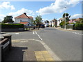
1
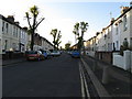
Southfield Road Broadwater Worthing
Now a cul-de-sac accessible from the west.
Image: © Dave Spicer
Taken: 29 Nov 2012
0.05 miles
2
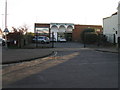
Alexander suppliers of kitchens, bathrooms and bedrooms
Situated at the east end of Southfield Road the showroom was about 30 years ago an early B & Q.
Image: © Dave Spicer
Taken: 29 Nov 2012
0.08 miles
3
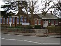
Whytemead First School
First school for students aged 4 to 8. Originally opened in 1930s as Dominion Road junior mixed and infant school. Became first school in 1974
Image: © WorthingMan
Taken: 15 Feb 2009
0.17 miles
4
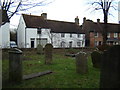
The old bakery in Broadwater Street East
18th century cottages. The white cottage was formerly Swifts, copyhold Broadwater Manor. The first baker from the 1860's onwards was William Manwaring, then the Knight family 1910-49.
Image: © Leigh Lawson
Taken: 2 Jan 2006
0.18 miles
5
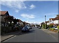
Looking westwards from Leigh Road into Charmandean Road
Image: © Shazz
Taken: 26 Sep 2015
0.18 miles
6
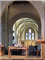
Interior of St Mary's Broadwater
This church dates from mid to late 12th century although there is a church mentioned here in the domesday book 1086.
Image: © Martin Dawes
Taken: 7 Oct 2017
0.19 miles
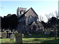
7

St Mary's Church, Broadwater
The building dates from the 12th century.
Image: © Kevin Gordon
Taken: 5 Feb 2008
0.19 miles
9
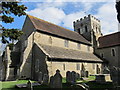
St Mary?s Church Broadwater, Worthing
Some Norman remains, 13th century Nave, additions through the century’s until major restoration in the Victorian era.
Image: © Richard Rogerson
Taken: 4 Apr 2012
0.19 miles
10
Beaumont Road, Broadwater, Worthing
A residential road developed in the late 1920s that links Sompting Avenue, the B2223, with Congreve Road.
Image: © Simon Carey
Taken: 31 Mar 2024
0.20 miles