IMAGES TAKEN NEAR TO
Bramley Road, WORTHING, BN14 9DT
Introduction
This page details the photographs taken nearby to Bramley Road, BN14 9DT by members of the Geograph project.
The Geograph project started in 2005 with the aim of publishing, organising and preserving representative images for every square kilometre of Great Britain, Ireland and the Isle of Man.

There are currently over 7.5m images from over14,400 individuals and you can help contribute to the project by visiting https://www.geograph.org.uk
Image Map
Images are licensed for reuse under creativecommons.org/licenses/by-sa/2.0
Notes
- Clicking on the map will re-center to the selected point.
- The higher the marker number, the further away the image location is from the centre of the postcode.
Image Listing (15 Images Found)
Images are licensed for reuse under creativecommons.org/licenses/by-sa/2.0
Image
Details
Distance
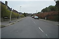
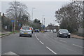
4
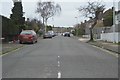
Looking westwards from Leigh Road into Charmandean Road
Image: © Shazz
Taken: 26 Sep 2015
0.13 miles
7
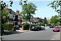
Third Avenue
An area of large individual houses to the north-east of Worthing.
Image: © Graham Horn
Taken: 25 May 2009
0.20 miles
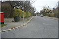
8
1-4, Downlands Parade, Upper Brighton Road, Broadwater, Worthing
The parade was built in the late 1940s or early 1950s and is located at the junction with Sompting Road.
Image: © Simon Carey
Taken: 22 Jul 2020
0.20 miles
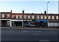
10
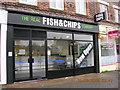
The Real Fish & Chip Company
Fish & Chip shop at Lyons Farm / Downlands Parade.
Image: © Mr Real
Taken: 10 Mar 2008
0.21 miles