IMAGES TAKEN NEAR TO
Clarendon Road, WORTHING, BN14 8QE
Introduction
This page details the photographs taken nearby to Clarendon Road, BN14 8QE by members of the Geograph project.
The Geograph project started in 2005 with the aim of publishing, organising and preserving representative images for every square kilometre of Great Britain, Ireland and the Isle of Man.

There are currently over 7.5m images from over14,400 individuals and you can help contribute to the project by visiting https://www.geograph.org.uk
Image Map
Images are licensed for reuse under creativecommons.org/licenses/by-sa/2.0
Notes
- Clicking on the map will re-center to the selected point.
- The higher the marker number, the further away the image location is from the centre of the postcode.
Image Listing (22 Images Found)
Images are licensed for reuse under creativecommons.org/licenses/by-sa/2.0
Image
Details
Distance
1
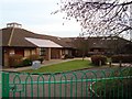
Bramber First School
First school for students aged 4 to 8 in Broadwater
Image: © WorthingMan
Taken: 15 Feb 2009
0.09 miles
3
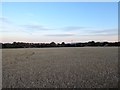
The Meadow
The name of the field according to Sompting's 1840 tithe map located to the south of Upper Brighton Road.
Image: © Simon Carey
Taken: 22 Jul 2020
0.13 miles
4
Allington Road, Broadwater, Worthing
A residential road linking Upper Brighton Road to Bramber Road that was built in the late 1930s.
Image: © Simon Carey
Taken: 22 Jul 2020
0.14 miles
5
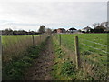
Path to Bramber First School
Public footpath 3135 from Upton Farm House.
Image: © Peter Holmes
Taken: 23 Feb 2016
0.15 miles
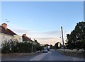
6
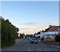
Bramber Road, Broadwater, Worthing
A residential road linking Upper Brighton Road to Bramber First School that was built in the late 1930s.
Image: © Simon Carey
Taken: 22 Jul 2020
0.15 miles
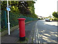
7
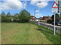
Allington Road / Bramber Road Village Green (1)
North east corner at junction between Allington Road and Upper Brighton Road.
Image: © Peter Holmes
Taken: 28 Apr 2015
0.18 miles
8
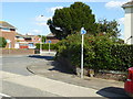
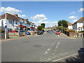
Junction of Allington and Upper Brighton Roads
Image: © Shazz
Taken: 26 Sep 2015
0.18 miles
10
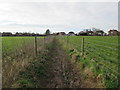
Route to Bramber First School
Public footpath 3135 from Upton Farm House, Upper Brighton Road.
Image: © Peter Holmes
Taken: 23 Feb 2016
0.18 miles