IMAGES TAKEN NEAR TO
Livesay Crescent, WORTHING, BN14 8AS
Introduction
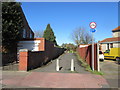
This page details the photographs taken nearby to Livesay Crescent, BN14 8AS by members of the Geograph project.
The Geograph project started in 2005 with the aim of publishing, organising and preserving representative images for every square kilometre of Great Britain, Ireland and the Isle of Man.

There are currently over 7.5m images from over14,400 individuals and you can help contribute to the project by visiting https://www.geograph.org.uk
Image Map
Images are licensed for reuse under creativecommons.org/licenses/by-sa/2.0
Notes
- Clicking on the map will re-center to the selected point.
- The higher the marker number, the further away the image location is from the centre of the postcode.
Image Listing (50 Images Found)
Images are licensed for reuse under creativecommons.org/licenses/by-sa/2.0
Image
Details
Distance
1
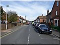
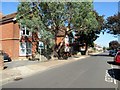
Westbourne Avenue, Broadwater, Worthing
A residential road linking Broadwater Road, the A24, with Garrick Road that was developed in the 1920s.
Image: © Simon Carey
Taken: 31 Mar 2024
0.06 miles
2
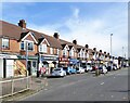
32-68, Broadwater Road, Broadwater, Worthing
A parade of shops on the eastern side of the A24 built in the 1920s.
Image: © Simon Carey
Taken: 31 Mar 2024
0.06 miles
3
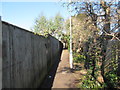
Footpath to Broadwater
Public footpath 3137. Direct route north from Worthing High Street.
Image: © Peter Holmes
Taken: 17 Feb 2015
0.08 miles
4
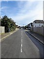
St Wilfred's Road, Broadwater, Worthing
A residential road linking Georgia Avenue and Cecilian Avenue that was developed in the 1920s.
Image: © Simon Carey
Taken: 31 Mar 2024
0.09 miles
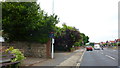
5
Path between King Edward Avenue and Westbourne Avenue
Public footpath 3137. Direct route north from Worthing High Street.
Image: © Peter Holmes
Taken: 17 Feb 2015
0.09 miles
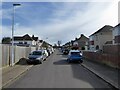
6
Broadwater Road, Approaching Junction with Northcourt Road
Image: © Richard Cooke
Taken: 5 Jun 2018
0.09 miles
7
Evelyn Road, Broadwater, Worthing
A residential road developed in the 1920s that links Georgia Avenue in the north to Cecilian Avenue to the south.
Image: © Simon Carey
Taken: 31 Mar 2024
0.10 miles
8
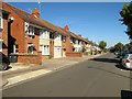
King Edward Avenue, BN14 8DB
Semi-detached houses.
Image: © Peter Holmes
Taken: 30 Aug 2016
0.10 miles
9
King Edward Avenue, BN14 8DB
Semi-detached houses some divided into flats.
Image: © Peter Holmes
Taken: 30 Aug 2016
0.11 miles
10
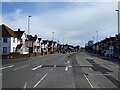
Broadwater Road, Broadwater, Worthing
The current A24 dates from 1803 when it was opened as a new turnpike linking the growing resort of Worthing directly from Broadwater. The previous route had been via what is now South Farm Road to the west. Development on the western side began from the 1890s whilst the eastern side was not added to until the 1920s.
Image: © Simon Carey
Taken: 31 Mar 2024
0.11 miles