IMAGES TAKEN NEAR TO
Broomfield Avenue, WORTHING, BN14 7RX
Introduction
This page details the photographs taken nearby to Broomfield Avenue, BN14 7RX by members of the Geograph project.
The Geograph project started in 2005 with the aim of publishing, organising and preserving representative images for every square kilometre of Great Britain, Ireland and the Isle of Man.

There are currently over 7.5m images from over14,400 individuals and you can help contribute to the project by visiting https://www.geograph.org.uk
Image Map
Images are licensed for reuse under creativecommons.org/licenses/by-sa/2.0
Notes
- Clicking on the map will re-center to the selected point.
- The higher the marker number, the further away the image location is from the centre of the postcode.
Image Listing (157 Images Found)
Images are licensed for reuse under creativecommons.org/licenses/by-sa/2.0
Image
Details
Distance
1
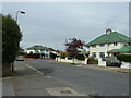
Two green tiled houses in Broomfield Avenue
Looking towards its eastern junction with Lavington Road.
Image: © Basher Eyre
Taken: 2 Apr 2011
0.01 miles
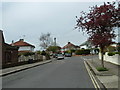
2
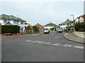
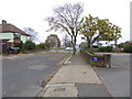
Looking from Broomfield Avenue into Lavington Road
Image: © Basher Eyre
Taken: 2 Apr 2011
0.01 miles
3
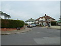
Eastern junction of Broomfield Avenue and Lavington Road
Image: © Basher Eyre
Taken: 2 Apr 2011
0.01 miles
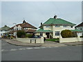
6
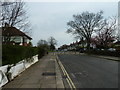
Dead end at the eastern end of Broomfield Avenue
Image: © Basher Eyre
Taken: 2 Apr 2011
0.02 miles
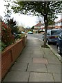
9
The east end of Broomfield Avenue
See also http://www.geograph.org.uk/photo/2402660.
Image: © Shazz
Taken: 1 Nov 2015
0.04 miles
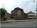
10
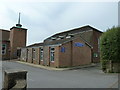
Methodist church at the eastern end of Broomfield Avenue
Image: © Basher Eyre
Taken: 2 Apr 2011
0.05 miles