IMAGES TAKEN NEAR TO
Watersfield Road, WORTHING, BN14 7QA
Introduction
This page details the photographs taken nearby to Watersfield Road, BN14 7QA by members of the Geograph project.
The Geograph project started in 2005 with the aim of publishing, organising and preserving representative images for every square kilometre of Great Britain, Ireland and the Isle of Man.

There are currently over 7.5m images from over14,400 individuals and you can help contribute to the project by visiting https://www.geograph.org.uk
Image Map
Images are licensed for reuse under creativecommons.org/licenses/by-sa/2.0
Notes
- Clicking on the map will re-center to the selected point.
- The higher the marker number, the further away the image location is from the centre of the postcode.
Image Listing (108 Images Found)
Images are licensed for reuse under creativecommons.org/licenses/by-sa/2.0
Image
Details
Distance
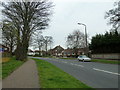
1
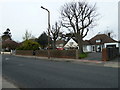
Approaching the junction of St Lawrence Avenue and Rectory Road
Image: © Basher Eyre
Taken: 2 Apr 2011
0.11 miles
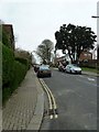
3
Junction of Nutbourne Road and St Lawrence Avenue
Image: © Basher Eyre
Taken: 2 Apr 2011
0.13 miles
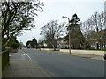
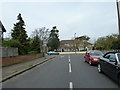
6
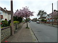
Looking eastwards in St Lawrence Avenue
Taken from South Street.
Image: © Basher Eyre
Taken: 2 Apr 2011
0.14 miles
7
Approaching the junction of Nutbourne Road and St Lawrence Avenue
Image: © Basher Eyre
Taken: 2 Apr 2011
0.14 miles
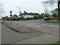
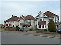
9
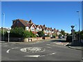
Loxwood Avenue, Worthing
Loxwood Avenue is a minor residential road in Worthing. This image shows the mini-roundabout at the junction with another minor road, Wiston Avenue.
Image: © Malc McDonald
Taken: 2 Jul 2022
0.14 miles