IMAGES TAKEN NEAR TO
Downview Road, WORTHING, BN14 0UU
Introduction
This page details the photographs taken nearby to Downview Road, BN14 0UU by members of the Geograph project.
The Geograph project started in 2005 with the aim of publishing, organising and preserving representative images for every square kilometre of Great Britain, Ireland and the Isle of Man.

There are currently over 7.5m images from over14,400 individuals and you can help contribute to the project by visiting https://www.geograph.org.uk
Image Map
Images are licensed for reuse under creativecommons.org/licenses/by-sa/2.0
Notes
- Clicking on the map will re-center to the selected point.
- The higher the marker number, the further away the image location is from the centre of the postcode.
Image Listing (75 Images Found)
Images are licensed for reuse under creativecommons.org/licenses/by-sa/2.0
Image
Details
Distance
2
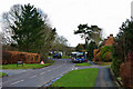
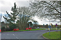
Bus route 1 at the bus stop
A Stagecoach bus bound for Worthing at the top end of Findon village. Beyond is the A24 junction, with no right turn.
Image: © Robin Webster
Taken: 26 Feb 2010
0.02 miles
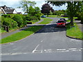
3
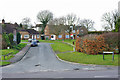
Horsham Road
The old course of the A24 as its south into the village of Findon, the road became a minor one when the bypass was constructed in 1938. The crossroads has Downsview Road heading off to the left and Homewood to the right.
Image: © Simon Carey
Taken: 13 Jul 2013
0.03 miles
4
Beech Road
A residential road linking Downsview Road to Stable lane that was developed in the 1960s on fields once belonging to Findon Farm.
Image: © Simon Carey
Taken: 13 Jul 2013
0.03 miles
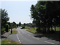
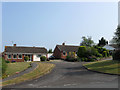
6
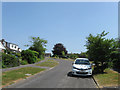
Downview Road
A residential road that heads east off Image and was developed in the 1960s on a field known as Hen Plat Field according to Findon's 1839 tithe map that belonged to Findon Farm.
Image: © Simon Carey
Taken: 13 Jul 2013
0.04 miles
7
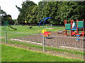
Homewood
A cul-de-sac that runs west off Horsham Road that was developed in the 1960s on a field of the same name. The green area is a small playground.
Image: © Simon Carey
Taken: 13 Jul 2013
0.06 miles
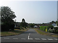
9
Junctions at north end of Findon
The old route through the village meets the A24 bypass.
Image: © Robin Webster
Taken: 26 Feb 2010
0.07 miles
10
Beech Close
Small cul-de-sac off Beech Road that was developed in the 1960s in fields once belonging to Findon Farm.
Image: © Simon Carey
Taken: 13 Jul 2013
0.07 miles