IMAGES TAKEN NEAR TO
Lime Road, WORTHING, BN14 0UL
Introduction
This page details the photographs taken nearby to Lime Road, BN14 0UL by members of the Geograph project.
The Geograph project started in 2005 with the aim of publishing, organising and preserving representative images for every square kilometre of Great Britain, Ireland and the Isle of Man.

There are currently over 7.5m images from over14,400 individuals and you can help contribute to the project by visiting https://www.geograph.org.uk
Image Map
Images are licensed for reuse under creativecommons.org/licenses/by-sa/2.0
Notes
- Clicking on the map will re-center to the selected point.
- The higher the marker number, the further away the image location is from the centre of the postcode.
Image Listing (96 Images Found)
Images are licensed for reuse under creativecommons.org/licenses/by-sa/2.0
Image
Details
Distance
1
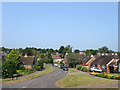
Lime Road
A residential road running between Beech Road and Horsham Road that was developed in the 1960s on fields that once belonged to Findon Farm.
Image: © Simon Carey
Taken: 13 Jul 2013
0.02 miles
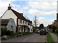
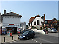
3
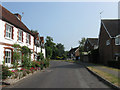
Rose Cottage, Horsham Road
The flint and brick building dates from the 18th century. Beyond is the junction with Image
Image: © Simon Carey
Taken: 13 Jul 2013
0.03 miles
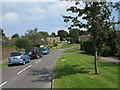
4
The Willows
A small development off Horsham Road that was built on the site of the former barns and outbuildings of Findon Farm during the 1960s. Out of shot on the right is Image
Image: © Simon Carey
Taken: 20 Jul 2013
0.04 miles
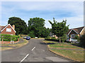
5
Residences in Findon
This section of residential area is in the extreme north western section of the grid square, but north of the pub an post office in the next grid square.
Image: © Pam Brophy
Taken: 16 Apr 2005
0.04 miles
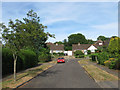
6
Elm Rise
A small cul de sac off Beech Road that was developed in the 1960s after the fields of Findon Farm were sold. Another development, Horseshoe Close, has been added at the top of the short road.
Image: © Simon Carey
Taken: 26 Jul 2013
0.05 miles
7
Ash Close
A small cul de sac off Beech Road, which can be seen at the end of the road, which was developed in the 1960s from fields once worked by Findon Farm. Viewed from a footpath that links the close to Image
Image: © Simon Carey
Taken: 26 Jul 2013
0.06 miles
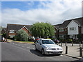
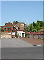
9
Findon Post Office
Located on Horsham Road just to the north of Image The post office occupies the former Findon Farmhouse.
Image: © Simon Carey
Taken: 13 Jul 2013
0.06 miles
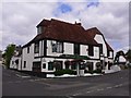
10
Tajdar, Horsham Road
The local village curry house just a little to the north of The Square opposite Image
Image: © Simon Carey
Taken: 13 Jul 2013
0.07 miles