IMAGES TAKEN NEAR TO
Horsham Road, WORTHING, BN14 0TQ
Introduction
This page details the photographs taken nearby to Horsham Road, BN14 0TQ by members of the Geograph project.
The Geograph project started in 2005 with the aim of publishing, organising and preserving representative images for every square kilometre of Great Britain, Ireland and the Isle of Man.

There are currently over 7.5m images from over14,400 individuals and you can help contribute to the project by visiting https://www.geograph.org.uk
Image Map
Images are licensed for reuse under creativecommons.org/licenses/by-sa/2.0
Notes
- Clicking on the map will re-center to the selected point.
- The higher the marker number, the further away the image location is from the centre of the postcode.
Image Listing (51 Images Found)
Images are licensed for reuse under creativecommons.org/licenses/by-sa/2.0
Image
Details
Distance
1
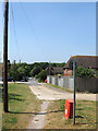
Road With No Name
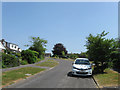
The road has a number of named cul-de-sacs branching off it but no designated appellation itself though it follows the course of an old bridleway. It was developed from the 1930s onward.
Image: © Simon Carey
Taken: 13 Jul 2013
0.02 miles
2
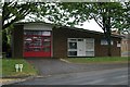
Findon Fire Station
Findon Fire Station, Horsham Road, Findon, West Sussex
Image: © Kevin Hale
Taken: 7 May 2007
0.04 miles
3
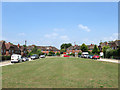
The Oval
A small estate built off Image during the 1930s on part of what was North Common Field.
Image: © Simon Carey
Taken: 13 Jul 2013
0.05 miles
4
Nightingales
A small cul-de-sac off Image that was developed in the 1990s on a field once known as Kingswood Front Meadow according to Findon's 1839 tithe map.
Image: © Simon Carey
Taken: 13 Jul 2013
0.05 miles
5
Highbarn
A small cul-de-sac off Image that was built during the 1960s when much of the northern end of Findon was developed.
Image: © Simon Carey
Taken: 13 Jul 2013
0.06 miles
6
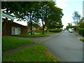
Bridleway at the north of Findon
Although a surfaced road here the way does not appear to be named. After about a furlong the bridleway passes beyond the houses into open country. On the left is the fire station.
Image: © Shazz
Taken: 9 Jun 2012
0.07 miles
7
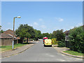
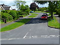
Bus route 1 at the bus stop
A Stagecoach bus bound for Worthing at the top end of Findon village. Beyond is the A24 junction, with no right turn.
Image: © Robin Webster
Taken: 26 Feb 2010
0.07 miles
9
Downview Road
A residential road that heads east off Image and was developed in the 1960s on a field known as Hen Plat Field according to Findon's 1839 tithe map that belonged to Findon Farm.
Image: © Simon Carey
Taken: 13 Jul 2013
0.07 miles
10
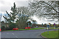
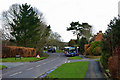
Junctions at north end of Findon
The old route through the village meets the A24 bypass.
Image: © Robin Webster
Taken: 26 Feb 2010
0.07 miles