IMAGES TAKEN NEAR TO
Nepcote, WORTHING, BN14 0SN
Introduction
This page details the photographs taken nearby to Nepcote, BN14 0SN by members of the Geograph project.
The Geograph project started in 2005 with the aim of publishing, organising and preserving representative images for every square kilometre of Great Britain, Ireland and the Isle of Man.

There are currently over 7.5m images from over14,400 individuals and you can help contribute to the project by visiting https://www.geograph.org.uk
Image Map
Images are licensed for reuse under creativecommons.org/licenses/by-sa/2.0
Notes
- Clicking on the map will re-center to the selected point.
- The higher the marker number, the further away the image location is from the centre of the postcode.
Image Listing (48 Images Found)
Images are licensed for reuse under creativecommons.org/licenses/by-sa/2.0
Image
Details
Distance
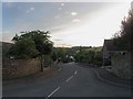
1
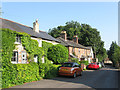
Cottages and Chapel, Nepcote
Nepcote is the name of the both the lane and the small hamlet which has now largely been engulfed by the village of Findon. The ivy clad dwellings on the left are Millbrook Cottages with York Terrace to its immediate right. At the end of the row is Nepcote Chapel built in the late 19th century. In the distance is Image
Image: © Simon Carey
Taken: 6 Jul 2013
0.02 miles
2
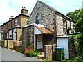
Nepcote Chapel
This is in Nepcote Lane and there has been no significant change since the first submission at http://www.geograph.org.uk/photo/2525935.
Image: © Shazz
Taken: 23 Jun 2012
0.02 miles
3
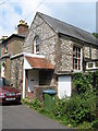
Nepcote Chapel in Nepcote Lane
What a tiny chapel!
Image: © Josie Campbell
Taken: 28 Jul 2011
0.02 miles
4
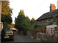
Elder Cottages, Nepcote
19th century flint built cottages that are located opposite the chapel on the lane called Nepcote that runs through the hamlet of the same name.
Image: © Simon Carey
Taken: 26 Jul 2013
0.03 miles
5
Nepfield Close
A cul de sac located off Nepcote that is a fairly recent development built on the site of an old sawmill.
Image: © Simon Carey
Taken: 26 Jul 2013
0.04 miles
6
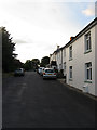
Cottages, Nepcote
On the eastern side of the lane that shares its name with the hamlet.
Image: © Simon Carey
Taken: 26 Jul 2013
0.04 miles
7
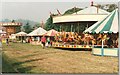
The Fair at Findon
The Findon Sheep Fair always includes fairground rides.
Image: © Peter Jeffery
Taken: 1 Sep 1999
0.06 miles
8
Threshers, Nepcote
The cottage was built in the 17th century and was originally two separate dwellings.
Image: © Simon Carey
Taken: 6 Jul 2013
0.07 miles
9
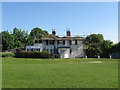
Nepcote House
Originally built as two cottages in the 18th century it was converted some time in the early 19th century into a beer house called the Running Horse which it remained until closure in 1924 whereupon it was converted into a single residence. The building lies on the south west boundary of Nepcote Green.
Image: © Simon Carey
Taken: 8 Jun 2013
0.08 miles
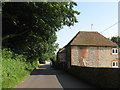
10
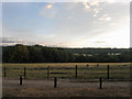
Nepcutt Field
The name of the field according to Findon's 1839 tithe map. Once a much larger field the southern part is the only remaining portion of the field still undeveloped and lies to the rear of Image, the rest has now been taken up with Image and Image The trees on the left mark the course of Image whilst in the distance is West Hill.
Image: © Simon Carey
Taken: 26 Jul 2013
0.09 miles