IMAGES TAKEN NEAR TO
Nepcote Lane, WORTHING, BN14 0SE
Introduction
This page details the photographs taken nearby to Nepcote Lane, BN14 0SE by members of the Geograph project.
The Geograph project started in 2005 with the aim of publishing, organising and preserving representative images for every square kilometre of Great Britain, Ireland and the Isle of Man.

There are currently over 7.5m images from over14,400 individuals and you can help contribute to the project by visiting https://www.geograph.org.uk
Image Map
Images are licensed for reuse under creativecommons.org/licenses/by-sa/2.0
Notes
- Clicking on the map will re-center to the selected point.
- The higher the marker number, the further away the image location is from the centre of the postcode.
Image Listing (111 Images Found)
Images are licensed for reuse under creativecommons.org/licenses/by-sa/2.0
Image
Details
Distance
1
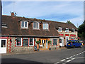
The Steakhouse Tapas & Grill, Nepcote Lane
Lying opposite the junction with Cross lane and near Image For many years this was the site of the old village forge which continued in operation until the early 1990s. The old flint building was then completely refurbished and turned into a bar and later the current restaurant.
Image: © Simon Carey
Taken: 26 Jul 2013
0.01 miles
2
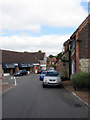
Shops, Nepcote Lane
Despite its closeness to Worthing the village still retains a number of shops and services. In view here on the left hand side of the road are the village shoe shop and a tearoom called Julia's Kitchen which serve rather nice breakfasts. The junction with Cross Lane is also on the left.
Image: © Simon Carey
Taken: 20 Jul 2013
0.01 miles

4

Always closed
Sign at the erstwhile Post Office in Findon.
Image: © Shazz
Taken: 30 Jul 2010
0.02 miles
5

The Old Post Office at Findon
See also http://www.geograph.org.uk/photo/1987930 .
Image: © Shazz
Taken: 30 Jul 2010
0.02 miles
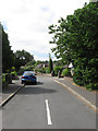
6
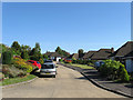
Downland Close
A small cul de sac off Stable Lane built sometime during the 1960s on the site of what was once, according to Findon's 1839 tithe map, Warehouse Field.
Image: © Simon Carey
Taken: 8 Jun 2013
0.03 miles
7
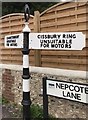
Old Direction Sign - Signpost by Nepcote Lane, Findon parish
Annulus finial - 2 arms; WSCC parish halo by the UC road, in parish of Findon (Arun District), junction of Nepcote Lane with Stable Lane.
To be surveyed
Milestone Society National ID: SX_TQ1208
Image: © Milestone Society
Taken: Unknown
0.03 miles
8
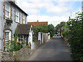
Kenseys, Cross Lane
Small cottage dating from the 18th century. In the distance is the junction with Nepcote Lane.
Image: © Simon Carey
Taken: 20 Jul 2013
0.04 miles
9
Tudor Close
A cul de sac leading off Nepcote Lane that was developed during the 1960s.
Image: © Simon Carey
Taken: 20 Jul 2013
0.04 miles
10
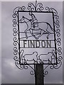
Village sign at Findon
This is in a small park on the corner of School Hill and Stable Lane.
Image: © Shazz
Taken: 30 Jul 2010
0.05 miles