IMAGES TAKEN NEAR TO
Northend, Findon, WORTHING, BN14 0RQ
Introduction
This page details the photographs taken nearby to BN14 0RQ by members of the Geograph project.
The Geograph project started in 2005 with the aim of publishing, organising and preserving representative images for every square kilometre of Great Britain, Ireland and the Isle of Man.

There are currently over 7.5m images from over14,400 individuals and you can help contribute to the project by visiting https://www.geograph.org.uk
Image Map
Images are licensed for reuse under creativecommons.org/licenses/by-sa/2.0
Notes
- Clicking on the map will re-center to the selected point.
- The higher the marker number, the further away the image location is from the centre of the postcode.
Image Listing (9 Images Found)
Images are licensed for reuse under creativecommons.org/licenses/by-sa/2.0
Image
Details
Distance
1
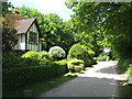
Keeper's Cottage
Located on the drive to Muntham Farm and originated as a 19th century lodge to the farm.
Image: © Simon Carey
Taken: 2 Jun 2013
0.02 miles
2
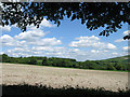
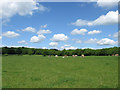
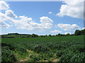
The Horse Wicks
The name of the field according to Findon's 1839 tithe map that has been expanded to include Image to the east. The western slope of Chanctonbury Hill can be seen in the distance.
Image: © Simon Carey
Taken: 2 Jun 2013
0.10 miles
3
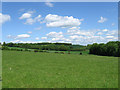
Ten Acres and Ramsdean
The name of the field according to Findon's 1839 and Washington's 1841 tithe maps that has been extended to include Image to the west. The portion of the field that lies within the parish of Washington is the top north-east corner.
Image: © Simon Carey
Taken: 2 Jun 2013
0.14 miles
4
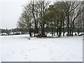
Cattle feeding in clump of trees at Muntham farm
Image: © Dave Spicer
Taken: 19 Dec 2010
0.15 miles
5
New Cottages, North End
The western pair of two sets of semi-detached cottages built on the drive to Muntham Farm in the 1950s.
Image: © Simon Carey
Taken: 2 Jun 2013
0.19 miles
6
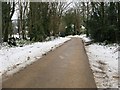
Concrete road from the A24 to Muntham Farm and Cobden Farm
This road and bridleway had been cleared of snow and ice for its entire length.
Image: © Dave Spicer
Taken: 19 Dec 2010
0.20 miles
7
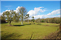
Barn Field
The name of the field according to Findon's 1839 tithe map that lies to the immediate north of Muntham Farm. The wood surrounding the field is known as The Groves.
Image: © Simon Carey
Taken: 2 Jun 2013
0.23 miles
8
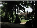
Over the crematorium fence
Pleasant parkland, presumably once the grounds of Muntham Court, the same as the crematorium.
Image: © Robin Webster
Taken: 1 Mar 2010
0.24 miles
9
The Green Wicks
The name of the field according to Findon's 1839 tithe map. Church Hill can be seen in the distance.
Image: © Simon Carey
Taken: 2 Jun 2013
0.24 miles