IMAGES TAKEN NEAR TO
Sullington Gardens, WORTHING, BN14 0HR
Introduction
This page details the photographs taken nearby to Sullington Gardens, BN14 0HR by members of the Geograph project.
The Geograph project started in 2005 with the aim of publishing, organising and preserving representative images for every square kilometre of Great Britain, Ireland and the Isle of Man.

There are currently over 7.5m images from over14,400 individuals and you can help contribute to the project by visiting https://www.geograph.org.uk
Image Map
Images are licensed for reuse under creativecommons.org/licenses/by-sa/2.0
Notes
- Clicking on the map will re-center to the selected point.
- The higher the marker number, the further away the image location is from the centre of the postcode.
Image Listing (16 Images Found)
Images are licensed for reuse under creativecommons.org/licenses/by-sa/2.0
Image
Details
Distance
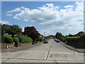
1
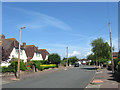
Hazelhurst Crescent, Findon Valley
A residential road connecting Central Avenue to May Tree Avenue which was developed during the 1930s after this part of the parish was transferred to Worthing.
Image: © Simon Carey
Taken: 30 Jun 2013
0.07 miles
2
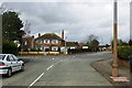
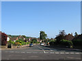
Crossroads, Findon Valley
Looking from Cissbury Gardens to Sullington Gardens across Central Avenue.
Image: © Robin Webster
Taken: 26 Feb 2010
0.09 miles
3
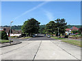
Central Avenue, Findon Valley
A wide tree lined avenue linking the eastern edge of the suburb to Findon Road, the A24. This part of Findon was transferred to Worthing in 1933 and subsequently developed during the rest of that decade. Salvington Hill is beyond.
Image: © Simon Carey
Taken: 30 Jun 2013
0.10 miles
4
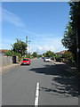
May Tree Avenue, Findon Valley
A residential road that links Central Avenue to Findon Road, the A24 that was developed from the 1930s after this part of the parish was transferred to Worthing.
Image: © Simon Carey
Taken: 30 Jun 2013
0.12 miles
5
Cissbury Drive, Findon Valley
A residential road that links Central Avenue to Findon Road which was developed in the 1930s after this part of Findon parish was transferred to Worthing.
Image: © Simon Carey
Taken: 6 Jul 2013
0.15 miles
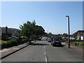
6
Sullington Gardens, Findon Valley
A residential road linking Storrington Rise to Central Avenue. Fondon Valley is the northern most suburb of Worthing and was developed towards the end of the 1930s having been transferred from the parish of Findon in 1933.
Image: © Simon Carey
Taken: 2 Jun 2013
0.15 miles
7
Long Meadow, Findon Valley
A residential road that runs from Storrington Rise to Central Avenue that was developed in the 1960s. Findon Valley is the northernmost suburb of Worthing and was developed from the 1930s onwards after parts of the arrea was transferred from the parish of Findon in 1933. The road itself is now a boundary between suburbia and the South Downs National Park.
Image: © Simon Carey
Taken: 2 Jun 2013
0.16 miles
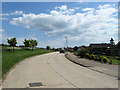
8
Junction Shepherds Mead, Long Meadow and Central Avenue
Image: © Josie Campbell
Taken: 29 Aug 2011
0.17 miles
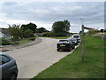
9
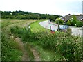
Footpath junction on Shepherds Mead
A view from another direction is at http://www.geograph.org.uk/photo/2576032.
Image: © Shazz
Taken: 15 Jul 2012
0.19 miles
10
Hollingbury Gardens, Findon Valley
A residential road that links Central Avenue to Coombe Rise which was developed during the 1930s after this part of the parish was transferred to Worthing.
Image: © Simon Carey
Taken: 30 Jun 2013
0.19 miles