IMAGES TAKEN NEAR TO
Lime Tree Avenue, WORTHING, BN14 0DP
Introduction
This page details the photographs taken nearby to Lime Tree Avenue, BN14 0DP by members of the Geograph project.
The Geograph project started in 2005 with the aim of publishing, organising and preserving representative images for every square kilometre of Great Britain, Ireland and the Isle of Man.

There are currently over 7.5m images from over14,400 individuals and you can help contribute to the project by visiting https://www.geograph.org.uk
Image Map
Images are licensed for reuse under creativecommons.org/licenses/by-sa/2.0
Notes
- Clicking on the map will re-center to the selected point.
- The higher the marker number, the further away the image location is from the centre of the postcode.
Image Listing (20 Images Found)
Images are licensed for reuse under creativecommons.org/licenses/by-sa/2.0
Image
Details
Distance
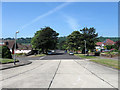
1
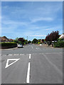
Lime Tree Avenue, Findon Valley
A residential road that links Fondon Road, the A24, to the south with Central Avenue in the north. In the foreground it crosses Image Much of the suburb to the east of Findon Road and north of Coombe Rise was once part of Findon parish until it was transferred to Worthing in 1933 after which this suburb was developed.
Image: © Simon Carey
Taken: 30 Jun 2013
0.02 miles
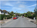
2
Cissbury Drive, Findon Valley
A residential road that links Central Avenue to Findon Road which was developed in the 1930s after this part of Findon parish was transferred to Worthing.
Image: © Simon Carey
Taken: 6 Jul 2013
0.07 miles
3

Findon Valley
A view of the suburb of Worthing from the bottom end of Image Much of the land here was once part of either West Tarring then Durrington or Findon parish all of which was transferred to Worthing between 1929 to 1933 after which the suburb began to be developed. Beyond is Mount Carvey with Sheepcombe Hanger the wood in the centre of the slope and Shipdens Holt to the left.
Image: © Simon Carey
Taken: 30 Jun 2013
0.08 miles
4
Cissbury Avenue, Findon Valley
A residential road linking Findon Road, the A24, with Cissbury Gardens that was developed from the 1930s onwards after this area of land was transferred from Findon parish to Worthing Borough Council.
Image: © Simon Carey
Taken: 30 Jun 2013
0.09 miles
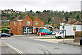
5
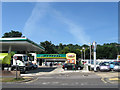
BP Connect, Findon Road, Findon Valley
Also containing Marks & Spencer which is always a sign of a more upmarket suburb.
Image: © Simon Carey
Taken: 30 Jun 2013
0.12 miles
6

The vet and the dentist
Crossways Veterinary Group and Findon Dental Care share the same block on the A24, Findon Valley.
Image: © Robin Webster
Taken: 26 Feb 2010
0.12 miles
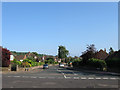
7
Central Avenue, Findon Valley
A wide tree lined avenue linking the eastern edge of the suburb to Findon Road, the A24. This part of Findon was transferred to Worthing in 1933 and subsequently developed during the rest of that decade. Salvington Hill is beyond.
Image: © Simon Carey
Taken: 30 Jun 2013
0.13 miles
8
Premises on A24 Findon Road
A restaurant or takeaway and 'Health-Haven' - osteopathy and the like.
Image: © Robin Webster
Taken: 26 Feb 2010
0.13 miles
9
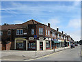
Kings Parade, Findon Valley
The northern end of this parade of shops viewed from the junction with Cissbury Avenue. The parade contains the usual range of local shops along with a Post Office and a Tesco Express.
Image: © Simon Carey
Taken: 30 Jun 2013
0.14 miles
10
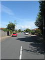
May Tree Avenue, Findon Valley
A residential road that links Central Avenue to Findon Road, the A24 that was developed from the 1930s after this part of the parish was transferred to Worthing.
Image: © Simon Carey
Taken: 30 Jun 2013
0.14 miles