IMAGES TAKEN NEAR TO
The Heights, WORTHING, BN14 0AJ
Introduction
This page details the photographs taken nearby to The Heights, BN14 0AJ by members of the Geograph project.
The Geograph project started in 2005 with the aim of publishing, organising and preserving representative images for every square kilometre of Great Britain, Ireland and the Isle of Man.

There are currently over 7.5m images from over14,400 individuals and you can help contribute to the project by visiting https://www.geograph.org.uk
Image Map
Images are licensed for reuse under creativecommons.org/licenses/by-sa/2.0
Notes
- Clicking on the map will re-center to the selected point.
- The higher the marker number, the further away the image location is from the centre of the postcode.
Image Listing (4 Images Found)
Images are licensed for reuse under creativecommons.org/licenses/by-sa/2.0
Image
Details
Distance
1
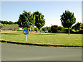
Grassy roundabout across The Heights, Findon Valley
The Heights is the road in the distance with the parked cars, running south from the roundabout. Behind the photographer's back is another stretch of the same road running north.
Image: © Slbs
Taken: 29 Jun 2008
0.14 miles
2
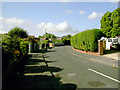
Northernmost stretch of The Heights, Findon Valley
The Heights is a pleasant residential road punctuated by a large roundabout.
Image: © Slbs
Taken: 29 Jun 2008
0.20 miles
3
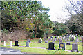
Durrington cemetery, northern edge
In general the older graves are at the northern end of the cemetery.
Image: © Robin Webster
Taken: 26 Feb 2010
0.21 miles
4
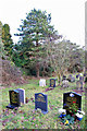
In Durrington Cemetery
By the northern boundary.
Image: © Robin Webster
Taken: 26 Feb 2010
0.24 miles