IMAGES TAKEN NEAR TO
New Dorset Street, BRIGHTON, BN1 3LL
Introduction
This page details the photographs taken nearby to New Dorset Street, BN1 3LL by members of the Geograph project.
The Geograph project started in 2005 with the aim of publishing, organising and preserving representative images for every square kilometre of Great Britain, Ireland and the Isle of Man.

There are currently over 7.5m images from over14,400 individuals and you can help contribute to the project by visiting https://www.geograph.org.uk
Image Map
Images are licensed for reuse under creativecommons.org/licenses/by-sa/2.0
Notes
- Clicking on the map will re-center to the selected point.
- The higher the marker number, the further away the image location is from the centre of the postcode.
Image Listing (1291 Images Found)
Images are licensed for reuse under creativecommons.org/licenses/by-sa/2.0
Image
Details
Distance
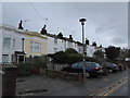
1
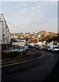
New Dorset Street
Once connected Church Street to the south and Upper Gloucester Road to the north but was truncated when St Nicholas's primary school was constructed in the 1960s. That redevelopment lost most of the houses in the street as the eastern side in view was primarily the rear of houses in Kew Street. The roofscapes reveal Brighton Station to the left and the top of Trafalgar Court to the right.
Image: © Simon Carey
Taken: 11 Jan 2009
0.00 miles
2
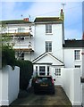
7a, North Gardens, Brighton
Originally the Rose & Crown public house that operated here from the 1820s to the 1970s. The bar occupied the ground floor and extended along the current driveway, originally a garden, to the pavement, see http://regencysociety-jamesgray.com/volume31/source/jg_31_136.html for a 1970 view. Now a private dwelling.
Image: © Simon Carey
Taken: 1 Nov 2015
0.01 miles
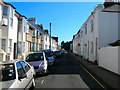
3
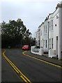
41-49, Centurion Road, Brighton
The road was developed in the 1850s and originally ran from Upper Gloucester Road to Church Street. In the 1960s the council decided to place St Paul's Primary School across this street as well as New Dorset Street after their original premises was earmarked for demolition as part of the Churchill Square development. The road now joins New Dorset Street to the left and runs in a loop back to Upper Gloucester Road. The i360 can be seen in the distance between the houses and foliage on the left.
Image: © Simon Carey
Taken: 1 Nov 2015
0.02 miles

7
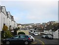
New Dorset Street, Brighton
Originally running between Upper Gloucester Road and Church Street and developed at various times between 1820 and 1840. The southern end was removed in the mid 1960s to accommodate St Paul's primary School who had to give up their previous premises to the Churchill Square development. Once a much narrower street many of the old cottages were removed in the 1930s with area beyond the yellow wall on the left filled with prefabs from 1947-67 and since replaced with garages. There are now only six dwellings on the street to the immediate left, the houses on the right are actually the rear of premises on North Gardens. In the distance is the roof of Brighton Station.
Image: © Simon Carey
Taken: 1 Nov 2015
0.04 miles
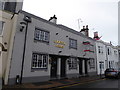
8
Centurion Road
Head east down Upper Gloucester Road then turn south into Centurion Road. More working class houses built up from the 1850s onwards. The road used to run into Church Street but was looped back to Upper Gloucester Road via New Dorset Street when the Infant school was expanded over the old southern entrance in the 1960s.
Click on the link to take you to the next page. http://www.geograph.org.uk/photo/212517
Image: © Simon Carey
Taken: 30 Jul 2006
0.04 miles

10

Sun Dial House, Queens Road
Head north up Queens Road to the junction with North Road, Sun Dial House is on the north east corner. The majority of the eastern side of Queens Road has been rebuilt over the past 40 years into by and large anonymous office blocks. Sun Dial House was built in 1896 for a mutual benefit society but sadly seems dwarfed by the current developments around it. The western side is largely unchanged.
Click on the link to take you to the next page. http://www.geograph.org.uk/photo/212551
Image: © Simon Carey
Taken: 30 Jul 2006
0.04 miles