IMAGES TAKEN NEAR TO
Dyke Road, BRIGHTON, BN1 3JS
Introduction
This page details the photographs taken nearby to Dyke Road, BN1 3JS by members of the Geograph project.
The Geograph project started in 2005 with the aim of publishing, organising and preserving representative images for every square kilometre of Great Britain, Ireland and the Isle of Man.

There are currently over 7.5m images from over14,400 individuals and you can help contribute to the project by visiting https://www.geograph.org.uk
Image Map
Images are licensed for reuse under creativecommons.org/licenses/by-sa/2.0
Notes
- Clicking on the map will re-center to the selected point.
- The higher the marker number, the further away the image location is from the centre of the postcode.
Image Listing (717 Images Found)
Images are licensed for reuse under creativecommons.org/licenses/by-sa/2.0
Image
Details
Distance
1
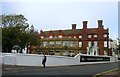
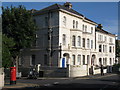
Royal Alexandra Quarter, Dyke Road, Brighton
The former Royal Alexandra Hospital has now been converted into flats. The original hospital opened in 1868 but moved to this purpose built site in 1881 where it remained until moved again to a new modern building to the rear of the Royal Sussex County Hospital. There were fears the building would be demolished, however, the main building has been retained and converted into flats. The extensions the hospital acquired over the years have gone with new flats built to replace them.
Image: © Simon Carey
Taken: 1 Nov 2015
0.01 miles

3
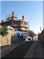
Former Royal Alexandra Children's Hospital
Opened in 1881 and closed in 2007 when the hospital moved to a new modern building behind the Royal Sussex Hospital. Since then there has been a stand off between the developers, Taylor Wimpey, who wanted to raze the entire site, and local residents and former patients who at least wanted the main facade kept. A compromise was finally reached in February 2011 whereby the locals got their wish but the developers were free to demolish the rest of the site. Demolition has started to the north but has yet to reach this part next to Clifton Hill.
Image: © Simon Carey
Taken: 19 Nov 2011
0.02 miles
4
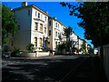
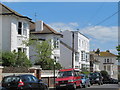
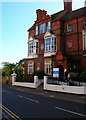
Dyke Road
Head west back down Westhill Road and then turn south down Dyke Road. At this point the road climbs to the peak of the hill before descending into Brighton town centre. The villas were constructed in the 1870s on the site of the original workhouse that was constructed in 1820 and moved in 1870 to Race Hill where the buildings are used by Brighton General Hospital today.
Click on the link to take you to the next page. http://www.geograph.org.uk/photo/212390
Image: © Simon Carey
Taken: 30 Jul 2006
0.03 miles
5
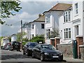
Dyke Road, BN1 (4)
North of Leopold Road. Shows the location of Image
Image: © Mike Quinn
Taken: 16 May 2012
0.03 miles
6
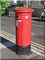
Victorian postbox, Dyke Road / Leopold Road
Image: © Mike Quinn
Taken: 23 Jun 2008
0.04 miles
9
Dyke Road / Leopold Road
Shows the location of Image
Image: © Mike Quinn
Taken: 23 Jun 2008
0.04 miles
10
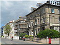
Royal Alexandra Children's Hospital
Head south down Dyke Road until the junction with Clifton Hill. The hospital original opened in 1868 but only moved to this building in 1881 where it has been ever since gradually expanding down the western side of Dyke Road.
Click on the link to take you to the next page. http://www.geograph.org.uk/photo/212397
Image: © Simon Carey
Taken: 30 Jul 2006
0.05 miles