IMAGES TAKEN NEAR TO
Long Furlong, WORTHING, BN13 3XN
Introduction
This page details the photographs taken nearby to Long Furlong, BN13 3XN by members of the Geograph project.
The Geograph project started in 2005 with the aim of publishing, organising and preserving representative images for every square kilometre of Great Britain, Ireland and the Isle of Man.

There are currently over 7.5m images from over14,400 individuals and you can help contribute to the project by visiting https://www.geograph.org.uk
Image Map (17 Images)


Getting Data...Please wait
Leaflet Map data © OpenStreetMap
Images are licensed for reuse under creativecommons.org/licenses/by-sa/2.0
Notes
- Clicking on the map will re-center to the selected point.
- The higher the marker number, the further away the image location is from the centre of the postcode.
Image Listing (17 Images Found)
Images are licensed for reuse under creativecommons.org/licenses/by-sa/2.0
Image
Details
Distance
1
Longfurlong Cottages
A pair of cottages on the A280 built in the latter part of the 19th century.
Image: © Simon Carey
Taken: 20 Jul 2013
0.01 miles
2
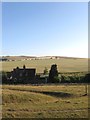
Longfurlong Barn
A large early 19th century barn that has now been converted into a wedding and corporate venue.
Image: © Simon Carey
Taken: 20 Jul 2013
0.03 miles
3
Longfurlong Barn
A grade II listed building on the A280, dating from about 1880, but according to the citation 'built in the tradition of a medieval tithe-barn'. Now a wedding and corporate venue, but this view is before the conversion.
Image: © Robin Webster
Taken: 20 Jun 2010
0.04 miles
4
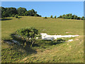
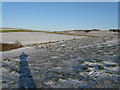
Old Chalk Pit
Located on Image and next to the footpath that links Longfurlong Barn with the village of Clapham. Clapham Woods lies above the brow of the hill.
Image: © Simon Carey
Taken: 20 Jul 2013
0.07 miles
5
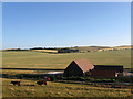
Longfurlong Barn
Taken from Longfurlong Lane and looking towards Clapham Woods which is on the ridge of the slope.
Image: © Simon Carey
Taken: 23 Sep 2006
0.08 miles
7
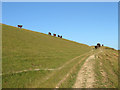
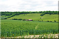
Tennants Down
The name of the field according to Clapham's 1843 tithe map that is located to the immediate south of Longfurlong, the A280. The cattle in the field have just wandered over to a drinking trough opposite Image and are now heading back to the shady side of the field to the west of Clapham Wood. The track contains the footpath that links the barn to the village.
Image: © Simon Carey
Taken: 20 Jul 2013
0.13 miles
8
Old Denshire/Barn Field/New Denshire
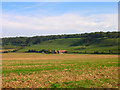
The name of the fields according to Clapham's 1843 tithe map viewed from Image The large field runs immediately to the north of the A280 with Old Denshire adjacent to the lane, Image lying behind Image and New Denshire abutting the parish boundary with Findon represented in the far distance by the hedgerow running north to south. Beyond is Church Hill. Denshire derives from 'Devonshiring' a method of fertilizing poor soils with burning.
Image: © Simon Carey
Taken: 27 Aug 2013
0.14 miles
9
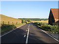
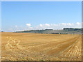
Longfurlong
The A280 as it passes Image The road was opened as a turnpike in 1823 and whilst it was never a success in the modern day it is a popular and busy route for motorists who wish to travel between the A24 and A27 without having to enter Worthing.
Image: © Simon Carey
Taken: 20 Jul 2013
0.17 miles
10
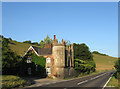
The Old Toll Gate
The only tollhouse built on the Longfurlong turnpike is located on the parish boundary between Findon and Clapham. It is believed the cottage on the left was the original building and may have originally been a lodge, the castellated portion on the right was added later and contains the window where the tolls were collected. The building later became tearooms and in 1970 were used to advertise Crown weatherproof paints with bottom part painted in a buff colour and the top part in white.
Image: © Simon Carey
Taken: 20 Jul 2013
0.18 miles